the visits before and
during the construction of the three gorges dam
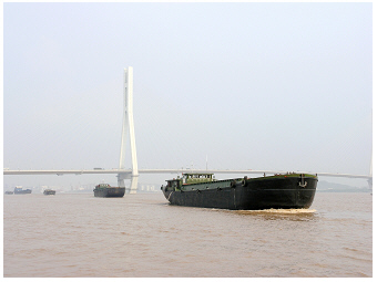 Yangtze River, at Nanjing,
2004:
Yangtze River, at Nanjing,
2004:
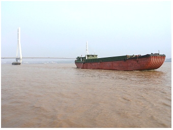
The lower stretch is an important waterway. Large vessels are
able to navigate this stretch.
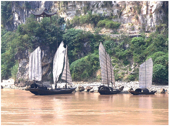 Yangtze River, middle stretch 2004:
Traditional Chinese river sailing boats, called 'junks' are seen on
the stony-rocky river shore. The boats are of different sizes
having only one, two or three sails, respectively.
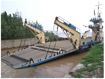 Yangtze River, at Nanjing,
2004:
Yangtze River, at Nanjing,
2004:
This roll-on/roll-off port near a village is built for a small double
ended vehicle ferry (see S). 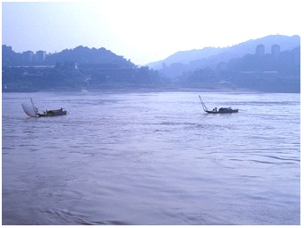 Yangtze River, middle
stretch 1997:
Yangtze River, middle
stretch 1997:
Traditional Chinese boats with lift nets are going fishing on the river
near Chongqing. Such scenery with fisher boats on Yangtze River was
only seen during the visit in 1997, not in 2004. A detailed description
of the operation of lift nets on fisher boats is given on this website
for a tributary of Yantze River at Yichang, the Huangbai, visited in
2004 (Yichang S).
For the largest River in Asia, Yangtze River (also called
Changjiang River or Yangzi River), the ecosystem
properties are as manifold as the long river channel diversity is
(see
also ‘the many faces’ of the mountain stream
Shennong Xi S,
which is a tributary of the Yangtze River, described on this
lakeriver-website). A few
photos shown here are from the broad channel of Yangzte
River downstream the city
Nanjing. The majority of photos, however,
illustrate the
middle stretch from Yichang to Chongqing, passing
the Three Gorges. Photos taken here are labeled according
to sections
Yichang-Badong and Badong-Chongqin stretch, respectively. The photo 70
in the top gallery shows a
tourist map with main cities and viewpoints
along the river that was displayed on a river cruise ship in 2004.
The photos were mainly taken in
2004, when the Three
Gorges Dam has been under construction with the aim to bring up the
water level to 175 m (see the water level mark on the photo in
the
paragraphs below). At that early stage of dam construction in 2004, the
water
level had been already reached 136 m (see more detail below).
In addition some photos that
were taken in
1997 were selected to show the riverbed many years before
the dam construction has been started. The damming up of Yangtze River
increased not only the water level of the main river channel, but also
of its tributaries as e.g. of the Shannon Xi mentioned before. Some
scenes shown by photos on this website are today beneath the
reservoir’s water level. In case of the Shibaozhai,
which was still
above the water when the dam construction was already ongoing in 2004,
a wall protects now the small island of the temple complex from water.
Another photo taken in 1997 shows traditional
wooden fisher boats with
lift nets seen on the main channel from the river. For
another
tributary of Yangtze River, the Huangbai River at
Yichang S,
the fishing
with the lift net is illustrated in great detail from the visit in
2004. Traditional fisherboats with lift nets were also common on lakes,
as shown for lake
Dianchi S
on this website in 2000/2001.
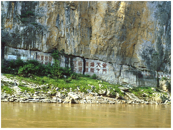 Yangtze River, Qutang
Gorge, 1997:
Yangtze River, Qutang
Gorge, 1997:
The four cliff inscriptions seen in this photo were engraved on the
'Chalk Wall' in different eras. At the time before the water
level rise started due to the dam
project, they were seen close down to the water's edge
of Yangtze. The green painted
inscriptions on the left side, for example, were written with
traditional
characters of gently curved lines. Someone has been taken care to
maintain these historical inscriptions such as those, for instance,
with
the large-size characters in red color are obviously looking freshly
painted. On the screen-sized photo that you get by mouse double-click,
all four inscriptions are seen on detailed inserts and can
be easily read.
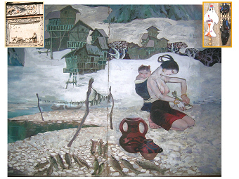 Yangtze River, BaiDi Cheng
- White Temple,
2004:
Yangtze River, BaiDi Cheng
- White Temple,
2004:
The main picture shows a water colour painting exhibited on the White
Emperor City. A young woman, who is carrying a child in a sling, is
preparing fish for drying on air
(stockfish, see also Taihu S).
Left insert: Wall modeling of the main entrance gate of the White
Temple: A water buffalo is used for ploughing the field. Such buffalos
were common livestocks in the Yangtze River basin (see also water
buffalos on Yangtze tributary Shannon Xi S
and lake Poyang S).
Right insert: Fish sculpture as modern art craft by local people
from Yichang.
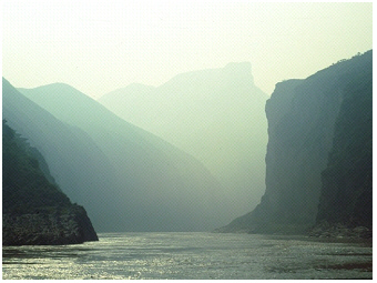 Yangtze River, Qutang
Gorge, 1997:
Yangtze River, Qutang
Gorge, 1997:
Scenic view from the boat at the White Temple (White
Emperor City) onto the gorge.
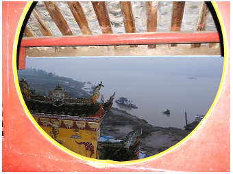 Yangtze River, Shibaozhai temple, 2004:
Scenic view from the temple onto the river at dusk. At that
early stage of the Three Gorge Dam construction, the temple
complex yet remains above the water level.
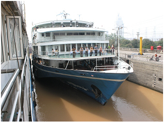
Yangtze River
cruises
have been popular over many years. The four photos below
depict the
cruise ships passing the ship lock at Gezhouba
Dam at Yichang and the
further upstream section. The following six photos relate to the cruise
passage at the Three Gorges
Dam.
 Popular river cruises on
Yangtze,
2004:
Popular river cruises on
Yangtze,
2004:
The ship locks at the Gezhouba Dam were built for large vessels. The
ships are taken upward and
downward to master the different water level
rise of about 21 to 25 (?) m.
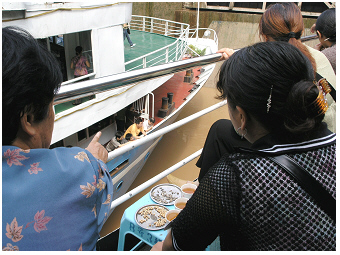 Popular river cruises on Yangtze,
2004:
Popular river cruises on Yangtze,
2004:
The ship is raised in the ship lock at Yichang. People
enjoy the time on board of the cruise ship.
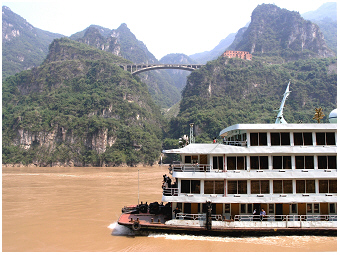 Popular river cruises on
Yangtze,
2004:
Popular river cruises on
Yangtze,
2004:
These large vessel are able to navigate through the midstretch of the
river. The river passes here rocky banks that look most
impressive.
 Popular river cruises on Yangtze,
2004:
Popular river cruises on Yangtze,
2004:
Hot water is all time freely available on board. In the past when
people suffered from having not
enough to eat and drink, plain 'hot water' was called 'white
tea'.
The following four photos give an impression about the huge
construction of the
Three Gorges Dam. The ships shown here are lifted
up through the passage of water level rise by
passing five locking
steps. Before the rise in water levels resulting from the
construction of the new reservoir,
housing areas and factories had to be removed from the river shore (see
photos below but also photos 32 and 60-64 in the top gallery).
As a consequence, during this early stage
of the dam project in 2004, deserted areas could be seen along the
middle stretch of the Yangtze River. The slope installations of water
level gauge boards and the signs for the 175 m were
placed at many
river sections and indicated the final water level reached by the Three
Gorge Dam construction. The photos
taken in 2004 are thus taken before
the water level further rises another 39 m.
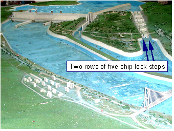 Yangtze River,
2004:
Yangtze River,
2004:
View on the model of the Three Gorges Dam with five locking steps.
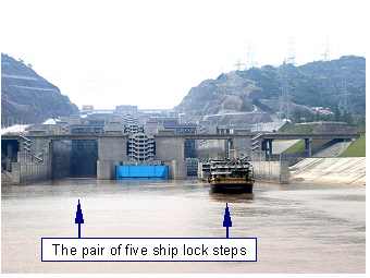 Yangtze River,
2004:
Yangtze River,
2004:
The pair of five ship locks is seen. Three cruise vessel enter the
locks
to pass the water level rise due to the Three Gorges Dam.
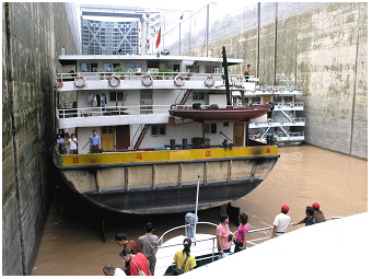
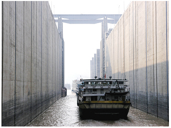 Yangtze top lock of the
five lock
steps of 2004:
Yangtze top lock of the
five lock
steps of 2004:
The vessels pass the top gate going further upstream.
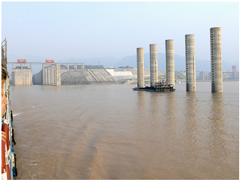 Yangtze River, Three Gorges Dam, 2004:
View back on the pair of locking steps on the left, and the Three
Gorges Dam
on the right side.
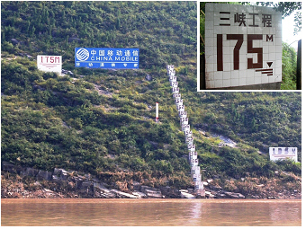 Sloping installation of a
water
level gauge board on the mid strech of Yangtze River,
2004:
Sloping installation of a
water
level gauge board on the mid strech of Yangtze River,
2004:
With the construction of the Three Gorges Dam, the water level rises
finally to 175m. At that early stage of the dam project, in 2004, the
water level of 136m has already been reached.
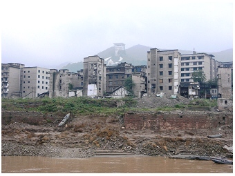 Yangtze River,
2004:
Yangtze River,
2004:
Deserted housing area in advance of the water level rise due to the
construction
of
the
Three Gorge Dam.
the low water transparency at the main
channel of yangtze river inhibits the growth of algae and other
phytoplankton species
The yellow-brownish color of the water of the Yangtze River and lakes in the Yangtze River
basin (e.g. such as
Poyang Lake S, turbidity at low and high water level seasons of
this large lake see Liu et al. (2016) R is perhaps
the most impressive aspect of their specific ecology. The extreme
water turbidity
is mainly due
to high concentrations of
suspended
solids (silt) washed in by
soil erosion from the surrounding landscape.
The
low water transparency becomes obvious simply by dipping
in a
plankton net,
which optically disappears few millimetres beneath the
water surface. To study algae in a plankton sample that contains that
large amount of suspended solids is challenging as photosynthetic
microorganisms are rare in the sample and overcrowded by plenty of
inorganic
particles from soil and sediment. The extraction method of analyzing
photosynthesis pigments might be here the more straightforward measure
of estimating their biomass than counting these microorganisms under a
light microscope. A common extraction method is to analyse
quantitatively chlorophyll-a,
as all planktonic primary producers, i.e.
algae and cyanobacteria, build this photosynthetic pigment (Greisberger
& Teubner
2007 R).
The
concentration of chlorophyll-a is thus used as a rough estimator for
total biomass of the photosynthetic microorganisms in a plankton
sample.
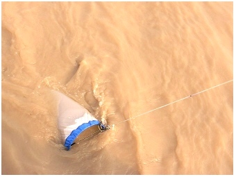 Yangtze River,
downstream at the city Nanjing, 2004:
Yangtze River,
downstream at the city Nanjing, 2004:
Dipping in the plankton net illustrates how low the transparency of the
river water is.
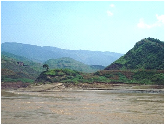
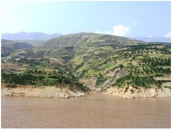 Yangtze River,
mid-stream, 2004:
Yangtze River,
mid-stream, 2004:
Karst landscape is bordering the river channel. Here the vegetation
cover does not prevent soil erosion on the steep slopes. Coarse gravel
is seen on the river bank.
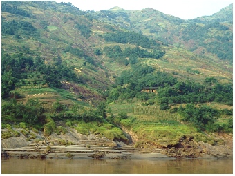
 Yangtze River, mid-stream,
1997:
Yangtze River, mid-stream,
1997:
The wide shallow river shore is a result of both soil erosion
and soil sedimentation. The bordering landscape is used for
growing
crops.
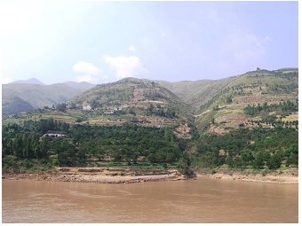
 Yangtze River, mid-stream, 1997:
The karst landscape in 1997 looks looks similar to the photo
above, taken 7 years later when the dam construction in progress. The
original river shore shown here, however, typically appeared shallower
and
wider and
contained more fine than coarse material as depicted here.
A
huge algal biomass in a flushed turbid river, in principle, cannot be
expected. The higher the flow velocity of a river and the
lower the
water transparency is (i.e. a lowered availability of
photosynthetically active radiation) the less photosynthetic
microorganisms will grow in the river, regardless of the nutrient
concentration in the river. In other words,
whereas planktonic algae are a good predictor for nutrient enrichment
in lakes, this is not the case in running waters. In
rivers of higher flow velocity, the number of
algal cells is
lower than in lakes with the same nutrient level as cell division is
mechanically inhibited in the river, and further cells are washed out.
In contrast to the situation in rivers, an increase of nutrient
concentrations in lakes
is usually promptly responded to by algal growth as is commonly seen by
the evolution of green algal blooms with nutrient enrichment in lakes
(eutrophication of lakes). Observing growth of photosynthetic
microorganisms in natural habitats implies that cells undergo cell
divisions. Under unlimited growth conditions during exponential growth
periods, e.g. in spring, about one cell division every day can be
expected in a lake (exponential growth phase in the spring).
 Yangtze River,
2004:
Yangtze River,
2004:
Terracing to prevent soil erosion.
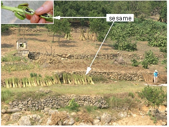 River bank of Yangtze,
2004:
River bank of Yangtze,
2004:
Crops on terraces: the harvest of sesame. Insert: matured fruits with
seeds of sesame plant.
Despite of the
growth-inhibiting effects of high flow-velocity
on algae, some algae can be even found in the main channel
river
plankton. These algae often originate from habitats of longer retention
time connected to the river, such as from small bay habitats at the
river
shoreline of a main stretch, from river side arms or even lakes. In the
situation where nutrient-rich river water enters a broadened stretch or
dam
reservoir, the water
residence time increases. As a consequence the
huge amount of suspended solids deposits immediately and in turn
water transparency increases. Sufficient
light
availability for
photosynthesis in addition to enhanced nutrient concentration
accumulated by the river stimulates algal growth
and may
promptly even turn the water colour
from sediment-brownish to
algal-green in a reservoir or lake (see details about Meiliang Bay of
the north of lake Taihu and related publications by Chen et al. 1993 R
and 1993 R discussed
on the
website for the
Shennong Xi S,
see also the page about lake
Taihu S).
 Yangtze River,
2004:
Yangtze River,
2004:
Chamber of a ship lock. The dark-green color of the wall is mainly due
to
the both photosynthetic pigments phycocyanin and chlorophyll-a that are
synthesized by micro-organisms. The
'Blue-Greens', i.e. cyanobacteria, built here the biofilm on the wall
in addition to other aquatic micro-organisms as algae and bacteria.
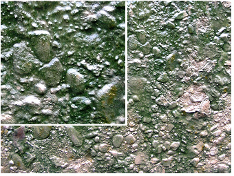 Yangtze River,
2004:
Yangtze River,
2004:
The blue-green color of the wall of the ship lock chamber is due to
attached living cyanobacteria as described for the left photo.
The filamentous
colonies of these photosynthetic micro-organisms can be macroscopically
seen (see screen-sized photo). Other photosynthetic micro-organisms, as
e.g. unicellular diatoms, also inhabit the biofilm, but are too small
and hence can be observed only under a light microscope.
While photosynthesis and thus the growth of floating algae in
the turbid water are inhibited, the photosynthetic
micro-organisms
attached to the wall of chambers of ship locks seen on the
photos above
can obviously grow well. The wall looks dark-green due to the biofilm built by the
‘blue-greens’, the cyanobacteria.
In addition to
chlorophyll-a, many cyanobacteria also produce blue-green
photosynthetic pigments, the ‘turquoise blue-green’ phycocyanin. The
growth of the cyanobacteria seen on the wall seems to correlate well
with the fluctuating water level. The time-intervals
of recurrent emptying
of the chamber are long enough to satisfy daily
photosynthesis
with sufficient
light. The underwater darkness by flooding the ship lock chamber might
interrupt photosynthesis but provides access to the nutrients that are
dissolved in the water. When the ship lock chamber is emptied again,
sufficient light for photosynthesis becomes available
and a thin water layer on the wet wall serves as ‘nutrient
solution/growing medium’. The uptake of some nutrients as phosphorus
depends on energy provided by photosynthesis and thus can
only succeed
during ‘day-time’ and ceases immediately at night or darkness.
Cyanobacteria and other primary producers, however, are able to utilize
even small concentrations of phosphate close to the chemical detection
limit within few minutes. Cyanobacteria can benefit from different
environmental conditions by various survival strategies, as e.g. by the
adjustment to light availability, and by the switch between an
autotrophic and heterotrophic life-style.
Cyanobacteria are
known to grow well even on rocks when water
is just available from time to time by rainfall. The cyanobacteria can
build different types of mucilage as for example described for
planktonic Microcystis
colonies on this website for lake
Taihu S. In
particular, thick mucilage
layers are usually built by cyanobacteria, not living
planktonically, but attached on stones in the splash of a
stream or on steep slopes of mountain rocks. The mucilage that envelops
the cyanobacterial cells
protects then against drying out too rapidly, damage
by UV and being washed out. A cyanobacterium, which is
found globally
on soil and can even survive longer dry periods, is Nostoc commune and
is further illustrated on this website.
Cyanobacteria are commonly associated with bacteria and other
photosynthetic microorganisms, floating or drifting in the water
(phytoplankton)
or living attached to the substrate as
stones on the
shore (phytobenthos).
The association of various species living
together can be very close. The enveloping mucilage produced by the
planktic
Microcystis
and that thus belongs to the Microcystis
aeruginosa
colony, can serve
further as a habitat for other species such as diatoms (Navicula) and other
cyanobacteria (Pseudanabaena
mucicola, see micrographs on page 48/49, Plate I,
fig.2 in
Teubner,
1996 R).
In addition to the benthic cyanobacteria,
mainly benthic diatoms that also produce sticky mucilage are
commonly found in biofilms.
The unicellular benthic
micro-organisms
can usually move in their micro-habitat. They are able to
glide to
places, there are not many shadows but also not too much light. In this
way, the organisms can avoid the both extremes, namely growth
limitation by low light internsity and cell damage by excessive light,
respectively. Watching a live sample under the light microscope, the
speedy movement of pennate diatoms or filamentous cyanobacteria gliding
on
the glass slide can be seen. It is known for pennate diatoms living
attached on stems of reed in the littoral, that they change their
position by migrating around the stem following the angle of incidence
of the
sun.
 >
>