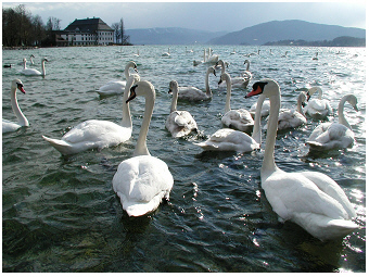
About lake attersee: The reference ecosystem for the lakes in Salzkammergut district in Austria
geographical location of the lake in the austrian alps and its ecology
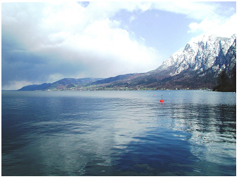 Lake Attersee, 2001:
View over the lake
from the south-west shore.
Lake Attersee (47°52’29.9''N,
13°32’54.5''E) is located in the Salzkammergut
district in
Austria at 469 m above sea level. This lake lies between
Mondsee
S
and Traunsee S, about 10 or
20 km away only. The three
alpine
lakes Attersee, Mondsee and Traunsee
are,
therefore, in close proximity. According to its lake water
volume of
3,945 x 106 m3,
Attersee is the largest lake
in Austria. The lake is further characterised by an area
of 45.9 km2 and a maximum depth of the
water basin of 170 m. Attersee is
hence 20 m
shallower than the deepest and second
largest lake
in Austria, lake Traunsee, but considerably
100 m deeper than Mondsee.
Despite the almost same lake depth for Attersee and Traunsee, the two
deep lakes are hydrologically very different.
The mean water
retention time of Attersee is
seven years and hence six years longer than that
of Traunsee (Table
1 in Dokulil & Teubner
2002 R,
Table
1 in Dokulil et al.
2006 R; see also the large
discharge of the River Traun and the history of salt mining in
case of the alpine lake Traunsee
S).
In view of lake ecology,
Attersee relates
closer
to the relatively shallow lake Mondsee than deep Traunsee,
as Attersee
and Mondsee
are located in
the same catchment disconnected to the catchment of Traunsee.
The nutrient status of Attersee is ultra-oligotrophic. The main limiting nutrient element, phosphorus, is particular low. Annual averages of total phosphorus concentration are usually below 0.5 µg per L. This nutrient-poor status corresponds to a low biomass of photosynthetic microorganisms and refers to chlorophyll-a values of 0.6-1.4 µg per L (Fig.8 in Dokulil & Teubner 2002 R). Secchi transparency depth in summer is still high, namely on average about 7-9 m in June and July. During the non-growing peak season Secchi depth is even much higher, namely e.g. about 19 m in early spring (see values for March in Fig.8 in Dokulil & Teubner 2002 R). According to low phosphorus concentration and various typical phytoplankton species, in concert with a common lake hydrology, lake Attersee is described as the reference ecosystem for alpine lakes in the Austrian Salzkammergut district by the rules of the European Water Framework Directive (WFD). The phytoplankton assessment of Austrian lakes in view of WFD (Dokulil & Teubner 2005 R) reveals that the phytoplankton biomass in lake Attersee is mainly built by species, which are known to be most abundant in oligotrophic alpine lakes (such lakes are popularly described as ‘nutrient-poor’, ‘natural pure-water’ or 'crystal-clear' lakes). In addition to this ecological assessment, aspects of the legal meaning of WFD, which refer again i.a. on Austrian lakes, are, for example, described in Berl (2014).
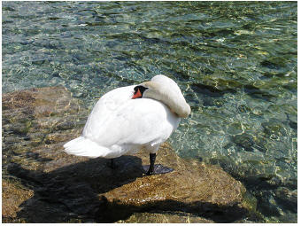 Lake Attersee, 2002:
The crystal-clear water
of Attersee convinces well of the reference ecosystem for all
the other alpine lakes in the Salzkammergut district.
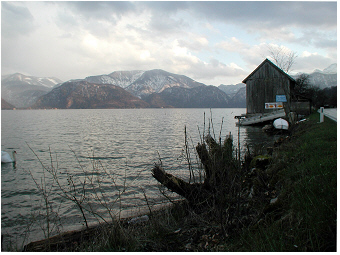 Lake
Attersee, 2001:
View over the lake from the west shore. The road (seen right
side of the picture) and areas used to build up new constructions are
almost everywhere close to the shoreline and are shrinking ecologically
valuable areas of the natural land-water
interface.
Lake Attersee is still a popular tourist attraction. The excellent transparency of lake water goes hand in hand with low-nutrition in the alpine catchment of the lake, benefiting from sustainable agriculture and sewage treatment plants. The pure lake water, however, goes not together with an ‘untouched nature’ of landscape near the shore. The road traffic is very close to the shoreline almost everywhere around lake Attersee. Natural habitats of the land-water interface (wet meadows) are largely replaced as traditional farming has been more and more substituted by vacation settlements. Limited areas of narrow rocky shorelines that are unsuitable for residential areas are still less impacted.
the catchment of alpine lakes in the Salzkammergut district: sustainable animal husbandry in lower valleys and higher pastures
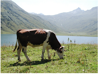 Traditional animal
husbandry in
the Salzkammergut lake district:
Livestock is
grazed in high pasture during summer.
Photo: Lake Tappenkarsee, 2002.
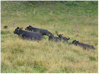 Traditional animal
husbandry
in the Salzkammergut lake district:
Suckler cow husbandry; herds are grazed in high pasture during summer.
Photo: Pasture 'Schafberg-Winkl',
2005.
Deep living Planktothrix rubescens is an exception to the rule of planktonic primary producers in a lake. Different from Planktothrix rubescens most photosynthetic organisms need much higher light intensities than dim light for photosynthesis. Hence the primary producers are growing in the surface layer in lake Mondsee. This lake surface layer inhabiting commonly photosynthetic organisms extends from the top 100% light intensity to deeper strata where at least 1% of surface light intensity is penetrating. This surface layer is called the euphotic zone. Phytoplankton organisms, however, are not necessary evenly distributed in the euphotic zone along the vertical profile. The near-surface maximum of phytoplankton biomass most days a year or at least on calm days without mixing by wind, is found at the shallow depth with 11-12% of surface light intensity. Such light intensities are typically found at 2-5m water depth in an alpine lake like Mondsee. At the very near surface, at 0-0.5m, usually not that many phytoplankton organisms are occurring in Mondsee as stress of high light intensity and UV radiation are inhibiting photosynthesis and hence reduce phytoplankton growth rates on the top surface of the lake.
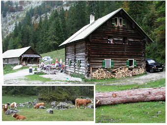
Traditional high pasture dairy farming in the Salzkammergut
lake district
:
In front is
seen the residential house of an alpine farmer family, taking care
their cattle in high pasture during summer time. The house is further
used as a small alpine restaurant/alpine hut ('Almhütte'
). The
cattle shed (small building left side) is here separately from the
residential house. This is rather different from common high pasture
dairy
farms where the residential area/restaurant is an annex building to the
cow stable.
Insert: Livestock is grazed in high pastures, suckler cow husbandry.
Photo: Lake Hinterer Gosausee, Pasture 'Holzmeisteralm', 2000.
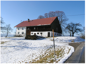 Traditional lower valley dairy farming in the Salzkammergut lake
district:
Many of such small modern stables are built according to the
traditional architecture where the residential area of farmer’s family
and the stable with the boxes for the cows are joined by an indoor
access. To run such a dairy farm by ‘living under one roof’ means to
take care the cows all day- and night-time, to milk them twice every
day the week and weekend, throughout the four seasons. Usually,
part-time farmers operate such small size farm facilities. This means
that the farmer is employed somewhere else and helps milking the cows
in the early morning (4 am) and late afternoon (4 pm) and is doing
other physically demanding farming work. The farmer’s wife, however,
does most of the taking care of the dairy cows, from milking to cattle
trade.
Photo: District Mondseeland,
2005.
Aquatic plants, called macrophytes, grow well on a wetland close to the shoreline or under-water (littoral) until at water-depth where sufficient light is still available for plant growth. The morphology of the water basin of deep alpine lake Mondsee refers to steep shores and hence, the shallow zone of the shore, the littoral zone of the lake, is narrow for macrophyte stands living in the water. In addition, a coarse grained sometimes even rocky underground at the bottom in the littoral zone, is not beneficial for macrophyte rooting and sprouting. Expanded macrophyte stands cannot be expected in lake Mondsee as found, for example, from riverine shallow lakes in North Europe or from mouths of large rivers as e.g. the Danube delta. Nevertheless, some macrophytes inhabit naturally the lake Mondsee. The macrophyte Phragmites australis for example, reed, occurs in lake Mondsee. This species is common in the world. Littoral reed belts are known to contribute to ecosystem health in many ways. They provide microhabitats for attached living algae (benthic algae, here mainly diatoms), which compete well for phosphorus and hence can be seen to control to some extent the growth of other algae as phytoplankton species. Further, non-living particles such as, for example, dead cells of phytoplankton, are settling in littoral reed stands. This organic material mineralised by microorganisms is fertilizing the sprouts of Phragmites. Underground rhizomes of Phragmites are known to contribute to an aeration of sediment. And it shouldn’t be forgotten that littoral reed belts serve as valuable habitats for many animals as molluscs, crustaceans, insects, fish and water birds.
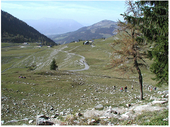 High pasture animal
husbandry in
the Salzkammergut lake district:
Mountain huts are embedded in high pasture.
Photo: Pasture 'Genneralm
Faistenau-Hintersee', 2002.
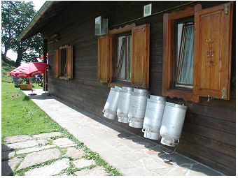 High pasture dairy
farming in the
Salzkammergut lake district:
The manageable number of milk churns seen on the photo refers to a
‘countable number' of cows being milked every day in the small
stable.
Traditionally, the annex to the stable serves as a living room for the
farmer family nighttime and as a small alpine restaurant
daytime in high mountain pasture. On sunny days, local food mainly
produced by the farmer’s family is served outside.
Photo: Pasture 'Genneralm
Faistenau-Hintersee', Hut Posch'n Hütte, 2002.
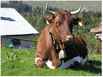 Traditional dairy
farming in the
Salzkammergut lake district:
Small mountain huts (‘Almhütten’) are nestled in high pastures and
invite to have a rest enjoying the local food that is prepared by the
farmer’s family. Such mountain hut is commonly the annex building to
the stable of the dairy cow farm.
Photo: Pasture 'Postalm',
Hut Postalmhütte, 2004.
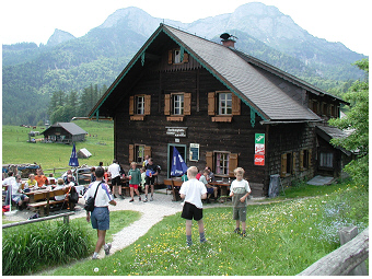 Traditional animal
husbandry Salzkammergut lake district:
In tourist regions, it is attractive for the farmer’s family to serve
food mainly produced by their own dairy farm. The food is prepared in
form of
popular simple dishes, e.g. cakes, salads, soups or cheese and cold or
hot sausages served with bred and milk.
Photo: Pasture 'Eisenaualm',
Hut Buchberghütte 2001.
The depth of the euphotic zone (euphotic depth) may vary among seasons and years. According to measurements of underwater light climate, the euphotic depth was on average at 11.3m in 1999 and at 11.1m in 2000 for lake Mondsee. In the case of only a few floating organisms, as in winter or in years of low nutrient concentrations, light is less absorbed or scattered by particles and can hence penetrate into deeper strata than at higher particle densities as in summer or nutrient-rich years. For practical reasons, the euphotic depth is usually not directly measured by a light sensor but is visually estimated by Secchi disc transparency (Secchi depth). Absorption and scattering properties by living particles containing even pigments are distinct from those of non-living particles and hence the conversion factor between both methods change with the season. During the growing season, when water transparency is mainly reduced due to living algal particles, i.e. from May to September, the Secchi depth might be multiplied by the factor 3.42 to calculate the euphotic depth.
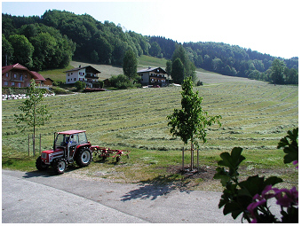 Sustainable dairy
farming in lower
valleys in the Salzkammergut lake district:
Farmer’s wife usually does haymaking on this farm. The tractor is
hence equipped with a child safety seat to take care of young children
while doing fieldwork.
Photo: District Mondseeland, 2001.
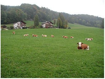 Sustainable dairy
farming in lower valleys
in the Salzkammergut lake district:
After the second time of haymaking, i.e in mid to late summer, the herd
is grazed daytime in low pasture until late autumn.
Photo: District Mondseeland, 2000.
cited References: about attersee
Berl, S. 2014. Streit um das wasserrechtliche Verschlechterungsverbot – was regelt dieses wirklich? Recht der Umwelt, Umwelt & Technik (RDU-U&T) 24/5: 70-78. Look-Inside FurtherLink
Dokulil, M. T., Jagsch, A., George, G. D., Anneville, O., Jankowski, T., Wahl, B., Lenhart, B., Blenckner T. & K. Teubner. 2006. Twenty years of spatially coherent deep-water warming in lakes across Europe related to North-Atlantic Oscillation. Limnol Oceanogr, 51 (6): 2787-93. doi:10.4319/lo.2006.51.6.2787 OpenAccess
Dokulil, M. & K. Teubner. 2005. Bewertung der Phytoplanktonstruktur stehender Gewässer gemäß der EU-Wasserrahmenrichtlinie: Der modifizierte Brettum Index. Deutsche Gesellschaft für Limnologoe (DGL), Tagungsand Karlsruhe, 5 pages. Look-Inside
Dokulil, M.T. & K. Teubner. 2002. Assessment of ecological integrity from environ-mental variables in an impacted oligotrophic alpine lake: Whole lake approach using 3D-spatial heterogeneity. Water Air Soil Poll, Focus , 2: 165-80. Look-Inside FurtherLink
Dokulil, M.T. & K. Teubner. 2002. The spatial coherence of alpine lakes. Verhandlungen der Internationalen Vereinigung für Theoretische und Angewandte Limnologie (Verh. Internat. Verein. Limnol.) 28, 1-4. Look-Inside
