About traunsee:
The most deep and second largest lake in Austria has a relative short
retention time
geographical location of the lake in the austrian alps
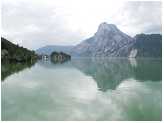
 Lake Traunsee, 2002:
View from the
Sonnstein Mountain onto the northern part of the lake basin. The
deepest site of 191 m is slightly further north from the
Traunkirchen
peninsula (seen on the west shore), is in the middle of the west-east
transect at the Traunstein Mountain, seen on the rocky east shore.
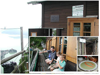 Lake Traunsee, 2002:
The
alpine hut on the Sonnstein Mountain ('Sonnsteinhütte')
with view onto the lake, is a
popular place to have a rest and to enjoy simple traditional dishes
prepared at 923 m above sea level. The hut is only
accessible
by foot on a mountain trail.
Lake Traunsee (47°52’16.9''N, 13°47’34.89''E) is at 422 m above the sea level in the Salzkammergut district in Austria. This alpine lake is only 20 km from Lake Attersee S, 35 km from Lake Mondsee S and 40 km from Lake Hallstaettersee S away. Traunsee has an elongated shape extending in the south-north direction, from the village Ebensee to the town Gmunden. With maximum depth of 191 m, Traunsee is the deepest lake in Austria. The lake area is 25.6 km2, and its water volume is 2302 x 106 m3. Compared with Lake Mondsee, Lake Traunsee is 2.7 times deeper and has a water volume 4.5 times larger than Mondsee. Even so, the theoretical water retention time of Traunsee, that is the time theoretically needed to renew hydrologically all the water in the lake, is one year only (Table 1 in Dokulil et al. 2006 R) . This is seven months shorter than for the shallower and smaller Mondsee. When comparing Traunsee with Lake Attersee, which is the lake with the largest water basin in Austria, Attersee has only about the double water volume but a seven times longer theoretical water retention time. The reason for the short water retention in the huge water basin is the large discharge of the River Traun[1], which flows from the south to the north through the lake. This river connects the saline lake Hallstätter See (retention time of a half year only) with Lake Traunsee so that these two lakes belong to the same catchment. Traunsee is hydrologically less connected with Attersee and Mondsee even if these two lakes are in the closer neighbourhood to Lake Traunsee than Hallstaettersee.
The temporal coherence among the three large lakes of the River Traun catchment, i.e. among Hallstätter See, Traunsee and Wolfgangsee, is highest for the lake pair Traunsee and Hallstätter See (Fig.2 in Dokulil & Teubner 2002 R, Table 3 in Dokulil & Teubner 2002 R). This coherence indicates a much closer synchrony of seasonal development of water temperature, various nutrients and plankton characteristics between Traunsee and Hallstätter See S than between lakes of the other lake pairs, as Traunsee-Wolfgangsee and Hallstätter See- Wolfgangsee (more about temporal coherence is presented in the section ‘climate response of lake Mondsee S').
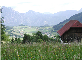 Lake Traunsee, 2002:
View from a flowering
meadow on the west shore onto the lake (Altmünster bay) and
the Traunstein Mountain.
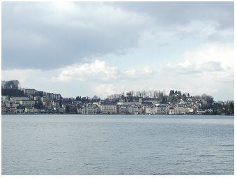 Lake Traunsee, 2001:
The largest town on the lake
is Gmunden,
located on the north shore at the outflow.
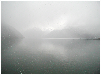 Lake Traunsee, 2001:
View onto the south
bay and the floating pipe bridge (right side of the photo) of
soda-production work in Ebensee.
Lake Traunsee is a popular place enjoying
scenic views in
the
Austrian Alps. Meadows, rocky shores and mountains mainly surround the
lake. The largest town on Lake Traunsee is Gmunden. This
town is
located at the outflow (!) and hence has never had a significant
eutrophication effect on the large water body of this alpine lake.
The nutrient-poor status of Lake Traunsee is still in
accordance with a
low-nutrition in the mountain catchment of this lake, benefiting from
sustainable agriculture and sewage-treatment plants.
Despite the nutrient-poor status, Lake Traunsee represents
NOT the
reference type of large deep alpine oligotrophic lakes as
aspects of unusual short water renewal time, enhanced turbidity and
salinity and potential effects of soda-production effluents affect
individually its lake ecology.
River Traun: a turbid plume flows through longitudinal the lake
The River Traun↑[1] is the main tributary of Traunsee and enters the lake on the south shore, the shallow bay areas close to the village Ebensee. The river passes the lake along the longitudinal extension from south to north and flows out at the town Gmunden. The water of the river mainly distributes small particles of inorganic material from the alpine catchment and riverbed into the lake which colours the lake azure blue slightly milky green. The turbidity of the water in Traunsee is hence highest in the south, at the inflow of River Traun (3D-lake-plots of turbidity in Fig.6 in Dokulil & Teubner, 2002 R). The lake becomes less turbid, the closer the water to the north end of the lake flows. Other lake parameters as e.g. the pH value, the chloride concentration and the conductivity values follow in principle this variation pattern of the longitudinal extension from the southern river inlet to the northern river outlet (Figs.4&7 in Dokulil & Teubner, 2002 R; see also the last paragraph of this page about the lake site impacted by industrial tailings by salt mining studied from December 1997 to October 1998). The nutrient ratio of nitrogen to phosphorus (N:P) at the water surface layer, however, revealed a different pattern than simply following the south-north transect. The ratio of N:P at water surface from 0 to 20 m seems to represent rather the depth heterogeneity of the large water basin comprising shallow bays and deep areas with steep slopes near the deepest site of 191 m (see N:P in Fig.7 in Dokulil & Teubner, 2002 R).
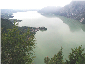
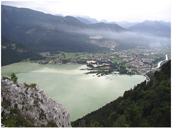 Lake Traunsee, 2002:
View from the Sonnstein
Mountain onto the south bay and the village Ebensee. The main
tributary, the River Traun, is seen in the
south valley on
the right side of the photo.
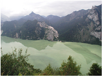 Lake Traunsee, 2002:
View from the Sonnstein
Mountain
onto the lake. The photo is taken in summer, when small particles of
inorganic material are largely discharged by the River Traun.
This river plume coulores the lake azure blue to milky green.
In this extreme nutrient-poor lake, the pale green
water
colour is hence NOT due to algae.
More than one-third of annual precipitation usually occurs in summer in the Traunsee district. July is the rainiest month contributing about 12 % to annual precipitation. After periods of high precipitation, the river plume of inorganic suspended solid material can be readily identified on the surface of the lake by measuring the turbidity along the vertical profile (see cloudy water in the both photos above). The water of River Traun, exemplified for the year 1999, was in August about 13 °C and hence stratified in the lake at a surface depth layer with corresponding water temperature (see depth profile T5 and T9 in Fig.5 in Dokulil & Teubner, 2002 R). The river plume horizon in the lake was then seen by a sharply stratifying turbid horizon in the top 6.5 to 20 m along the 140 m depth profile nearby the south bay. Even further away from the Traun-inflow, at the deepest site (called site Viechtau, 191 m depth), the stratifying plume showed up as an enhanced inorganic turbidity in the surface layer. River Traun hence affects Lake Traunsee twofold. The turbid river plume lowers water transparency in the nutrient-poor, i.e. oligotrophic, freshwater system. Further, the elevated river discharges contribute mainly to a rapid renewal of water in the huge freshwater basin.
the plankton in lake traunsee:
a deep lake without a chlorophyll maximum in the deep layer
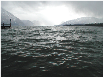 Lake
Traunsee, 2001:
The northern part
of the large lake with it's deepest site far from the north shoreline,
close to the Traunkirchen peninsula on the west shore (seen on the
right side of the foto) and the Traunstein Mountain on the east shore.
The lake is characterized by low nutrient availability for
growth of algae and photosynthetic bacteria drifting at the surface of
the water basin. In particular, the phosphorus
concentration is low. Total phosphorus, measured for
depth-integrated samples from 0-20 m, has an annual average of 7.5 µg
per L (0.24 µmol L-1) for the
deepest site and
8.7 µg per L (0.28 µmol L-1)
for the south
‘Ebensee’ bay (December 1997 to October 1998, Fig.2
in
Teubner 2003 R).
This nutrient-poor,
i.e.
oligotrophic state corresponds to a low biomass development of algae
and cyanobacteria in Traunsee. A rough estimator of this biomass is the
photosynthetic pigment chlorophyll-a as described in greater detail for
lake Mondsee
S.
The annual average of chlorophyll-a
concentration measured for depth-integrated samples
(0-20m) was at the deepest site of Traunsee 1.36 µg per L only. The
main chlorophyll development was found mid May-June with concentrations
of
2.37 µg per L associated with annual peaks
of photosynthetic rates (Fig.8
in
Dokulil & Teubner 2003 R, Fig.1
in
Teubner & Dokulil 2002 R).
In view of the poor nutrient availability, Traunsee
is
close to ultra-oligotrophic Attersee
S
(Fig.8
in
Teubner 2003 R).
The photosynthetic
microorganisms
drifting in the water, i.e. the phytoplankton
organisms in Traunsee belong to diverse algal groups
(diatoms, cryptophytes, dinoflagellates, chrysophytes, chlorophytes)
and cyanobacteria as is common in other lakes. As exemplified by the
year 1998, the diatoms
contributed with up to 93 % most to the phytoplankton in spring
in Traunsee (page 1587
in
Teubner 2003 R).
Seasonality of phytoplankton in 1998 can be mainly
described by diatom biomass changes. As diatoms specifically utilize
the nutrient element silicon, the top water layer of predominant
photosynthetic activity (0-20 m) coincided with relative high
silicon
exhaustion in comparison to the other two main nutrients as phosphorus
and nitrogen. The main diatom species in Traunsee were Aulacoseira
ambigua, Asterionella formosa, Tabellaria flocculosa, Fragilaria
crotonensis, F. ulna and various
unicellular centric diatoms. Cryptophytes contributed up to 55% of
total phytoplankton in late summer and autumn. Other algal groups as
dinoflagellates, chrysophytes, chlorophytes and cyanobacteria were of
minor importance and reached not more than 26% of the total biovolume
during the annual cycle.
In terms of the size
structure of
phytoplankton, the small organisms are much more abundant
in the plankton community of alpine lakes than those of large
biovolume. It could be shown, that in Lake Traunsee the small algae,
which refer here to the algal size fraction that has passed a filter
with the mesh-size of 10 µm, contributed far more than the half to
total chlorophyll (63% were measured for Traunsee, the same was valid
for Mondsee, page 316
in
Teubner et al. 2001 R).
Measuring photosynthesis
in Lake Traunsee, the small size fraction of phytoplankton (0-10µm)
indicated a relative high light utilization efficiency and relative
high portions of light-harvesting to photo-protective pigments than the
size fraction of larger cells (larger than 10µm, Figs.4&8,
Table 2
in
Teubner et al. 2001 R).
This allometric rule, that
cell size
determines photosynthetic properties, was not only
measured for phytoplankton in Traunsee, but also other for other alpine
lakes as Mondsee and Lucerne (Teubner
et al. 2001 R).
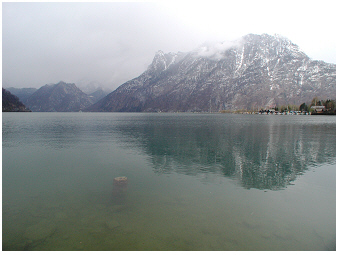 Traunsee, 2001:
Shallow shore at the south bay - slightly enhanced turbidity of water
due to inorganic
suspended solids. This shoreline is nearby the inflow of the river
Traun and the discontinuously operated outlet of industrial effluents
in Ebensee.
Carbon is a major element of biomass. The
carbon ratio of phytoplankton to bacterioplankton indicates the portion
between photosynthetic and non-photosynthetic microorganisms drifting
in the water column. The carbon ratio on the surface was 1.25 and
decreased moderately to 1 at 20 m for Traunsee in 1998 (Fig.4C
in
Teubner 2003 R).
These values
indicate the dominance of
photosynthetic microorganisms versus bacterioplankton at 0-20m.
This top layer coincides indeed with the main depth distribution of
algae and photosynthetic bacteria. In the year 1998, the chlorophyll-a
concentration of phytoplankton had an annual average of 1.6, 1.4 and
1.1 µg per L at 0.5, 10 and 20 m,
respectively. This distribution
pattern corresponded to the vertical light availability for
phytoplankton photosynthesis. The euphotic
zone, which refers to the top water layer where at least
1 % of light is penetrating, varied between 9-17 m
and has an annual
average of 12.2 m at the
deepest site (Table 1
in
Teubner & Dokulil 2002 R,
Fig.2
in
Teubner 2003 R).
The euphotic zone exceeded the mixing zone
by 2-3 m in Traunsee most of the time in summer as is commonly
found in
other alpine lakes (see e.g. Mondsee
S).
The zone of 0.01% light
intensity varied
from 14 to 26 m during growing season in Traunsee
and was
on average 19 m. The dim-light zone below the euphotic zone
was hence
at
12 to 19 m in Traunsee. In other alpine lakes, a chlorophyll
peak in
the
deep dim-light layer is found and refers to a phytoplankton peak
development in the metalimnion. Such a ‘deep chlorophyll maximum’,
which commonly occurs in moderately nutrient-enriched deep alpine
lakes, was not found in oligotrophic Traunsee. The deep phytoplankton
biomass peak in Mondsee and Ammersee was mainly built by the
cyanobacterium Planktothrix
rubescens, usually associated with low abundances of other
deep living algae such as diatoms and cryptophytes. Planktothrix
rubescens occurred even in Traunsee but was
rare. In the year 1998, this cyanobacterium was seldom found, in
September and December and contributed only 0.1-0.3 % to total
biovolume. From 20 to 40 m depth, the carbon ratio of
phytoplankton to
bacterioplankton decreased drastically in Traunsee, namely from 1 to
0.5, indicating the predominance of bacterioplankton. A few
phytoplankton cells may stratify ‘by chance’ even at 40 m
depth as low
chlorophyll-a concentrations of less than
0.4 µg per L at this dark
layer of deep metalimnion close to the hypolimnion were measured. The
metalimnetic layer avoids entrainment of particles as described in more
detail for Lake Mondsee.
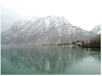 Traunsee, 2001:
The south site of large lake
Traunsee - the shallow Ebensee Bay is about 50 m deep only.
The signature that pelagic microorganisms are mainly
inhabiting the top 20 m layer, can also be seen by vertical
profiles of proportion among
the three fractions
of the total phosphorus pool, the annual DRP:DOP:POP
triple ratio. The top 20 m at the deepest site refer to high
portion of
particulate-biotic phosphorus (POP) than compared to the other two
fractions, the dissolved reactive-inorganic (DRP) and the mainly
dissolved organic phosphorus (DOP), respectively. From 20m to
40 m, the
portion of biotic phosphorus relative two the other two fractions
decrease drastically (Fig.5A
in
Teubner 2003 R).
The biotic fraction is the only fraction of
phosphorus that decreases over magnitudes with depth, while the
proportion between the two dissolved fractions, is more or less uniform
over depth with slight increases toward DRP near the bottom. Also the
annual mean of the TN:TP:SRSi ratio (Fig.5B&C
in
Teubner 2003 R),
which refers to the stoichiometric
proportions between the
main nutrient elements utilized by photosynthetic
organisms, i.e. nitrogen, phosphorus and silicon, designate the top
20 m
layer as the main phytoplankton layer indicated by a strong
silicon exhaustion relative to
N and P. As described for another lake, phosphorus is a
nutrient element of very short turnover time of about hours to days. As
a rule of the thumb, the turnover for nitrogen takes longer than for
phosphorus, from days to weeks. Both nutrient elements can be recycled
within a season and are hence promptly or fast replenished for algal
utilization. The turnover time needed of silicon is even longer,
usually weeks to months. For that reason, the replenishment of silicon
after exhaustion from near bottom layer is often linked to seasonal
events as mixing in deep (!) lakes. To take account of the rapidly or
in moderate time recycled phosphor and nitrogen, respectively, usually
the total phosphorus pool and also in many cases the total nitrogen
pool is chosen as the resource nutrient pool. In the case of silicon,
the dissolved fraction of soluble reactive silicon is the only
ecologically relevant nutrient source (and not total silicon), as
continuous supply is hampered by long turnover time. The mismatch in replenishment of the three
nutrient elements is also seen by the portions of
dissolved inorganic fractions of each element, DIN:DRP:SRSi (DIN is
dissolved inorganic nitrogen) in Traunsee (Fig.5B&C
in
Teubner 2003 R).
This triple ratio
follows,
in principle, the depth profile of TN:TP:SRSi except for phosphorus as
here the resource nutrient pool (SRP in the lake water) is consistently
underestimated.
Vertical depth distribution was not only found for algae and bacteria but also for planktonic micro-animals in Lake Traunsee. A particular high species richness along depth profiles with seasons was found for ciliate assemblages . More than 50 ciliate taxa could be identified in Traunsee. The most frequent ciliates were Rimostrombidium brachykinetum/Rimostrombidium hyalinum and Balanion planctonicum (list of species in Table 2, scheme of graphical illustration in Fig.5A in Sonntag et al. 2006 R). The seasonal pattern of depth distribution of these aquatic protozoa as ciliates and non-photosynthetic small flagellates (heterotrophic nano-flagellates), was mainly determined by the depth distribution of their potential food sources, e.g. algae and bacteria (Fig.4 in Sonntag et al. 2006 R). A strong increase or decrease of the abundance of ciliates, i.e. of positive or negative net-change of ciliate abundance by growth or loss at a certain time-interval, was necessarily associated with pronounced shifts in species composition. Further, the persistence of ciliate composition, was only found at time-intervals of (almost) zero abundance net-changes. These particular periods refer to an ecological steady state during seasonal development of ciliate assemblages. Such net-change response curves followed a bell-shaped distribution pattern and were not only valid for ciliate assemblages (Fig.2 in Sonntag et al. 2006 R), but also other plankton organisms (see phytoplankton in lake Ammersee S, Fig.7 in Teubner et al. 2003 R).
A multidisciplinary study was carried out to answer questionsto what extent the ecology integrity of Lake Traunsee was affected by industrial tailings by salt processing from soda works at the south bay, the ‘Ebenseer Bucht’. The biovolume and chlorophyll-a concentration of the planktonic photosynthetic microorganisms was at the site with the slight phosphorus enrichment, site Ebensee Bay, on average nearly the same when compared with the deepest site (see phytoplankton biovolume in Fig.2A&E in Teubner, 2003 R; see chl-a in Fig.8 in Dokulil & Teubner, 2002 R). According to the phosphorus availability at Ebensee Bucht, we could expect, however, an even higher biomass of plankton organisms. As seen from Fig.5A&D in Teubner (2003 R), about 11 % less phosphorus was bound by planktonic organisms to build up biomass at the impacted site Ebensee Bay when compared with the deepest site (based on annual average during the investigation period from December 1997 to October 1998). This relative (!) low value of microbial biomass in the surface layer at Ebensee Bay could be seen as an inhibition of primary producers due to lowered water transparency. According to in situ measurements of primary production, the phytoplankton at Ebensee Bay represented indeed a phytoplankton community, which was acclimated to low-light conditions (see significant higher values of the maximum light utilization coefficient for phytoplankton at Ebensee Bay than at the deepest site; Tables 1&2 in Teubner & Dokulil, 2002 R). Measurements of the underwater light-climate from April to October 1998 have shown that the euphotic zone (Zeu) was on average 2 m shallower at Ebensee Bay (Zeu = 10.2 m) than at the deepest site (Zeu = 12.2 m, Table1 & Fig.1F in Teubner & Dokulil 2002, R). This reduced water transparency in the bay was caused by turbidity due to industrial tailings and/or suspended solids inflowing by the River Traun during the investigation period from December 1997 to October 1998. Besides planktic community also benthic organisms, i.e. the organisms that live attached to shore line material as e.g. on the surface of stones, were in detail studied. It could be shown, for example, that the benthic diatom community adjusted to higher salinity nearby the inlet of industrial tailings when compared with other sites studied along the lakeshore of Traunsee (Wunsam et al. 2002 R). The species composition shifted here toward higher abundances of diatoms (e.g. Achnanthes minutissima), which are known to tolerate saline habitats. The indication of the saline environment by benthic diatoms was not well found in all seasons but was most pronounced and statistically significant during late autumn. The long-term development of concentrations of chloride and oxygen at lake surface and bottom layer are displayed for Lake Traunsee in graphs by Jagsch et al. (2002 R), and are discussed in a more detail on the lake Hallstaetter See S website when comparing the both saline lakes. The main outcome of other studies about the ecological integrity of Lake Traunsee in 1997 and 1998 is summarized in a special journal volume in aquatic sciences (Water Air Soil Pollution-Focus 2, 2002 ).
cited References: about traunsee
Dokulil, M. T., Jagsch, A., George, G. D., Anneville, O., Jankowski, T., Wahl, B., Lenhart, B., Blenckner T. & K. Teubner. 2006. Twenty years of spatially coherent deep-water warming in lakes across Europe related to North-Atlantic Oscillation. Limnol Oceanogr, 51 (6): 2787-93. doi:10.4319/lo.2006.51.6.2787 OpenAccess
Sonntag, B., Posch, T., Klammer, S., Teubner, K. & R. Psenner. 2006. Ciliates and flagellates in an oligotrophic deep alpine lake: contrasting variability with seasons and depths. Aquat Microb Ecol, 43: 193-07. doi:10.3354/ame043193 Look-Inside OpenAccess
Teubner, K. 2003. Phytoplankton, pelagic community and nutrients in a deep oligotrophic alpine lake: Ratios as sensitive indicators of the use of P-resources (DRP:DOP:PP and TN:TP:SRSi). Water Res, 37 (7): 1583-92. doi:10.1016/S0043-1354(02)00535-3 Look-Inside FurtherLink
Teubner, K., Tolotti, M., Greisberger, S., Morscheid, H., Dokulil, M.T. & H. Morscheid. 2003. Steady state phytoplankton in a deep pre-alpine lake: Species and pigments of epilimnetic versus metalimetic assemblages. Hydrobiologia 502: 49-64. Look-Inside FurtherLink
Dokulil, M.T. & K. Teubner. 2003. Steady state phytoplankton assemblages during thermal stratification in deep alpine lakes. Do they occur? Hydrobiologia, 502: 65-72. Abstract FurtherLink
Dokulil, M.T. & K. Teubner. 2002. The spatial coherence of alpine lakes. Verhandlungen der Internationalen Vereinigung für Theoretische und Angewandte Limnologie (Verh. Internat. Verein. Limnol.) 28, 1-4. Look-Inside
Teubner, K. & M. Dokulil. 2002. 14C-Photosynthesis of phytoplankton in an oligotrophic alpine lake (Traunsee, Austria) and its response to turbidity caused by industrial tailings. Water Air Soil Poll, Focus 2: 181-190. Look-Inside FurtherLink
Dokulil, M.T. & K. Teubner. 2002. Assessment of ecological integrity from environmental variables in an impacted oligotrophic alpine lake: Whole lake approach using 3D-spatial heterogeneity. Water Air Soil Poll, Focus , 2: 165-80. Look-Inside FurtherLink
Jagsch, A., Gassner, H. & M.T. Dokulil. 2002. Long-term changes in environmental variables of Traunsee, an oligotrophic Austrian lake impacted by salt industry, and two reference sites, Hallstättersee and Attersee. Water Air Soil Poll, Focus , 2: 9-20. FurtherLink
Wunsam, S., Kamenik, C. & R. Schmidt. 2002. Epilithic diatoms in an alpine lake (Traunsee, Austria) affected by soda and salt mining industries. Water Air Soil Poll, Focus , 2: 93-108. FurtherLink
Teubner, K., Sarobe, A., Vadrucci, M.R. & M. Dokulil. 2001. 14C photosynthesis and pigment pattern of phytoplankton as size related adaptation strategies in alpine lakes. Aquat Sci 63: 310-25. doi:10.1007/PL00001357 Look-Inside FurtherLink
