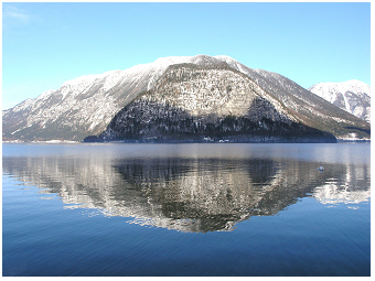
die geografische Lage des Sees in den
österreichischen Alpen
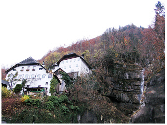
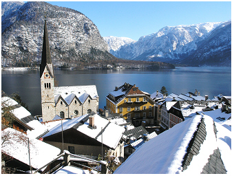
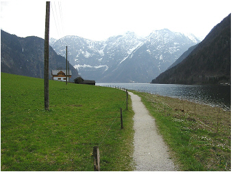
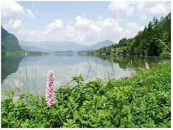 Alpiner Hallstätter See, 2000:
Blick vom Wanderpfad „Ostuferweg“ nordwärts auf den See.
Der Hallstätter See (47°34’26.8''N,
13°39’26.3''E)
ist
ein
alpiner See im Salzkammergut
in
Oberösterreich (Österreich),
der 508 m über dem Meeresspiegel liegt. The lake basin area is
8.6 km2,
the water volume 557 x 106 m3
and the maximum depth 125 m. The lake has an elongated shape,
which extends over a distance of about 8 km from north to
south. The deep lake belongs to
the same
catchment
as lake Traunsee.
The theoretical
water retention time of Hallstätter
See is a half-year only (Table
1 in Dokulil & Teubner
2002 R,
Table 1 in Dokulil et
al.
2006 R)
. This is even shorter than for lake Traunsee, having about a four
times higher lake water
volume than Hallstaetter See. As described for lake Traunsee, the
reason
for the particular short water retention despite the large size of deep
alpine water basins is the large discharge of the river
Traun, which
flows through both lakes.
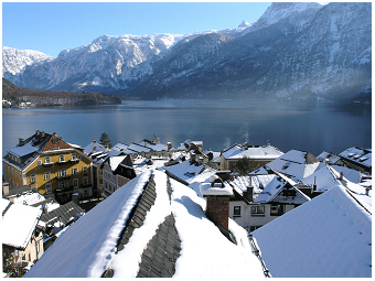
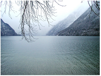 Alpine lake Hallstaetter See, 2001:
View southward onto the lake elongated between north and south. In the
back, on the west bank of the lake, the town Hallstatt can be seen.
The water retention time of large deep lakes,
however, is usually much longer, as already discussed on the website of
lake Traunsee
S
comparing Traunsee and Mondsee. Mondsee S
has about
the same water volume (510 x 106
m3)
as lake Hallstätter See, is also located in the Salzkammergut district
in Upper Austria but in the neighbouring catchment and has a
theoretical water retention time of 1.7 years. Lakes of very
short
water retention lasting from days to a few months are typically flushed
shallow lakes in lowland river-floodplains and are called 'riverine
lakes' S
and hence have a quite different limnology compared to that of
deep alpine
lakes.
The Hallstatt area is an
ancient place. The importance
of Hallstatt is mirrored in the eponymously named period of
Early Iron Age
(
‘Hallstatt’ culture). This populated site is also rich in
Late Iron
Age history (
‘Celtic’ culture). Palaeolimnological studies on sediments
of lakes in this alpine region describe very well the impact of climate
and
land use for this mountain area from these prehistoric periods until
recent times (see e.g. Schmidt et al. 2008 R
& 2009 R).
The medieval town Hallstatt
is located in the south of the
west bank of the lake. According to descriptions by Simony in 1866/67
(see page 51
in Grims 1996 R),
all
early morning many salt miners travelled in wooden barges
(boats) on lake Hallstaetter See to Hallstatt, and were then hiking
the
mountain Hallberg (Salzberg at Hallstatt) via serpentines to go to
work. Even in recent times, a
few decades ago, this small town was still a remote place as
paths on the western lake shore were too narrow to allow traffic to
pass to this
area. A tunnel system of
roads and parking terraces along the rocky west lake bank now
enables local people and visitors to get easy access to this
place.
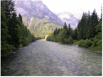 Fluß Traun, 2005:
Dieser Fluss durchfliesst die beiden Alpenseen Hallstätter See und
Traunsee. Der starke Traun-Durchfluss bewirkt eine relativ kurze
theoretische
Verweilzeit des Wassers in beiden Seen trotz der großen tiefen
Seebecken.
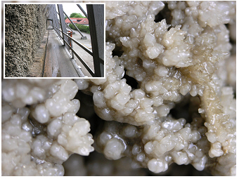 Stadt Bad Dürrenberg nahe der Stadt Halle,
2005:
Stadt Bad Dürrenberg nahe der Stadt Halle,
2005:
Sole wurde nicht nur für die Salzgewinnung im Mittelalter, sondern auch
für Heilzwecke und Wellness bis jetzt verwendet, wie es hier für die
Kurstadt Bad Dürrenberg (Deutschland) gezeigt ist. Auch die Orte in der
Nähe von Hallstatt (Österreich) waren beliebt für Wellness. Das Foto
zeigt Salzverkrustungen des Gradierwerkes. Eingefügtes Foto:
Gradierwerk mit Holzrahmenkonstruktionen, die mit Reisig von Prunus
spinosa
gefüllt sind. Die Sole wird von oben über die Reisigzweige verrieselt.
Mit der Verdunstung des Wassers lagern sich Salzkrusten auf dem Reisig
ab. Es wird gesagt, dass das Einatmen des Sole-Aerosols der Gesundheit
gut tut. Das Flanieren entlang eines Gradierwerks soll einem
Spaziergang am Meer gleichen.
Hallstatt is famous for
saltmining in the Austrian Alps. It is one of the oldest
salt
mining places around the world and was used for more than 7000 years.
It is suggested that the name ‘Hall’ does not refer to the word
‘salt’
of Celtic Language but to the technically newly introduced treatment
for salt crystallization commonly described in the language of High and
Middle German in the middle age, to the name of a processing plant,
where
underground brine is heated up
in a ‘salt pan’ (Sudpfanne,
Salzsiedepfanne, Saltzpan) to get solid salt (Stifter 2004/2005 R).
Simony wrote that the house with the salt pan was the heart of
Hallstatt , and that it was the working place for about 70-80 people
(“Das Pfannhaus ist das Herz Hallstatts,…”; page 52
in Grims 1996 R).
Such houses (Pfannhaus, Sudhaus, Siedehaus) with
‘Salzsiedepfannen’ were
frequently used to produce salt in the middle age in Europe, at places
where natural and artificially underground brine (in German ‘Sole’) was
available (e.g. the region around the city Halle in
Germany and
small
towns in the neighbourhood such as Bad Duerrenberg and Bad Koesen).
This
technique of salt production via underground produced brine was
efficient in the medieval period but
needed lots of firewood. High amounts of wood ash (in German ‘Asche’)
containing waste of salt compounds needed to be handled. In Bad
Duerrenberg,
a small town near Halle for example, the
waste of salt production by
encrustation of brine was transferred by small railway containers
(Loren, Güterloren)
to a salt mine waste tip (ash-salt tip, ‘Ascheberg
in Bad Dürrenberg’ at
‘Salinenstrasse’, road section between Ostrauer Strasse and Merseburger
Strasse, 51°18’2.1''N,
12°3'844.08''E). This salt mine tip is now moderately covered
by
vegetation.
Among other halophilic plants, dense stands of the yellow flowering
Horned Poppy (Glaucium flavum)
can be there found at the surface where
soil is mixed up with plate-shaped mineral salt crusts, the deposited
waste from salt pans. Different from Bad Dürrenberg in the low land,
in Hallstatt the area needed for the deposition of salt waste
was limited in the mountain environment. The ash-salt waste was
simply
dumped into the lake for hundreds of years. At the time of
the visits by Simony in 1866/68, one third of brine only was treated to
make salt in Hallstatt. The remaining brine was pumped via pipelines to
the village
Ebensee at Traunsee, to the ‘Sudwerk’ that was founded years ago, in
1607 (page 52
in Grims 1996 R).
In recent decades, the brine was not yet treated in
Hallstatt, but all transferred via pipelines to the plant in Ebensee at
lake Traunsee (see also on this website the effluence of mineral
industrial tailings in the recent period in Traunsee until the soda
production ended in 2005). Salt mining in
this alpine region played an important economic role but also
affected both the large lake ecosystems,
Traunsee and Hallstaettter See. The impact on Hallstaetter See is
shortly described in the following section about the limnology of this
lake. For Traunsee
S
see limnological details on the respective lake website.
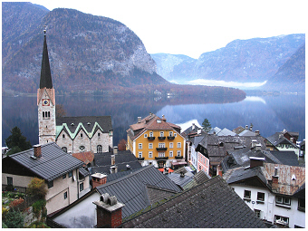
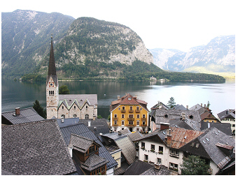
 Stadt Hallstatt am Hallstätter See, 2005.
Viele Häuser der kleinen mittelalterlichen Stadt sind in den steilen
Bergklippen am Ufer des Sees gebaut.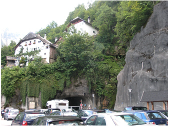 Dieselben Häuser wie auf
den Foto links,
aber 2010 fotografiert.
Dieselben Häuser wie auf
den Foto links,
aber 2010 fotografiert.
Autos werden in dieser kleinen Stadt, einem Ort mit einer alten
Kulturgeschichte, „gut versteckt“. Der Verkehr wird über ein
Tunnelsystem entlang dem Rand der Stadt geleitet. Besucher parken ihre
Autos auf den Tunnel-Terrassen an den Klippen oder auf Parkflächen, die
einen etwa 15-minütigen Spaziergang entfernt vom Stadtzentrum liegen.
Menschen Zuhörend:
'Ja, es ändert sich so manches mit
der
Zeit, gerade heutzutage, wo vieles leider so arg kurzlebig ist. Oft
denk’ ich so. Aber nicht, wenn ich hier auf der Terrasse steh’ und
hinunter auf das kleine Hallstatt schau. Hier ist alles noch wie es vor
Jahren war – zumindest über die Jahre gesehen, über die ich Hallstatt
von Zeit zu Zeit besucht habe. Hier kann ich mich darauf verlassen,
dass der Ort so aussieht, wie ich ihn schon oft geseh’n habe, am Ufer
vom kristallklaren Hallstätter See, eingebettet in die Berge! Das ist
Hallstatt! Wie oft war ich schon hier? Mit der Familie und mit
Freunden! Ich weiß nicht, wie oft ich schon auf dieser Terrasse
gestanden bin, wage es nicht mal dies grob abzuschätzen. Egal! Es zählt
halt
der Augenblick heute wieder einmal hier sein zu können, und das freut.
Und heute bin ich hier mit Joe. Ich dreh mich vom See weg und schau
verträumt hangaufwärts auf die weißen Häuser. Diese Häuser sind quasi
mit dem Berg verwachsen! Wie werden sie wohl innen aussehen? Wer
mich kennt, weiß wie gern ich dort mal einen Blick hineinwagen würde.
Diese Häuser faszinieren mich immer wieder von neuem, sodass es jedes
Mal ein Muss ist, sie nochmals zu fotografieren: mal sind sie
von Schnee umgeben, mal im
Regen, mal inmitten von Frühlingsgrün, in der gleißenden Sonne im
Sommer oder eingeschlossen in den bunten Herbstfarben der Sträucher und
Bäume. Und so fotografiere ich diese weißen Häuser auch heute wieder.
Wunderschön! Wenn ich diese Häuser betrachte, kommt mir kaum in den
Sinn, dass es für so manche Bergbaufamilie ganz sicher
nicht leicht war an diesem Ort zu leben. Ich genieße den Blick hinunter
auf den
kleinen Markt von Hallstatt und sage zu Joe: „Die Aussicht ist
herrlich! Und da oben, diese weißen Häuser, wie sie am Hang kleben, die
haben es mir besonders angetan. ’s muss wohl leicht beschwerlich sein,
seinen
wöchentlichen Einkauf dorthin zu tragen?! ABER ich glaub’ mit einem
zuverlässig funktionierenden Internetanschluss würde es mir gefallen
dort zu wohnen. Das wär’ urnett! Joe, könntest du dir auch vorstellen
hier zu wohnen?“ Joe antwortet nicht gleich, schaut vom Tal den Hang
rauf und wieder hinunter auf den See und meint dann allmählich: „Also,
ehrlich gesagt, für mich wär’ das nix. Ich würde hier nicht leben
wollen. Der Ort ist überhaupt nicht gut zum Leben.“ Und während er dies
sagt, schaut er leicht kopfschüttelnd über den See und das Tal dahin.
„Da
ist ja überhaupt kein Platz“, fährt er fort, „du kannst da keinen
Getreideacker haben, kein Viehzeug, nicht mal Hühner! Gar nichts! Und
überhaupt ist diese Bergwelt ja völlig ungeeignet für einen
Weingarten.“ Und hier überzieht nun ein Lächeln sein Gesicht. Mit
Augenzwinkern und abwinkender Hand fährt er munter fort: „Ja, ich würde
hier meinen Weingarten vermissen! Samt dem alten Kirschbaum!“ „Ach
komm, Joe“, sage ich, „wozu hat man einen Kirschbaum auf dem
Weinberg?“ „Ich kann dir sagen, wozu ein Kirschbaum gut ist“,
entgegnet
Joe lachend. „Früher haben sie oft Kirschbäume mitten in die
Weinberge gepflanzt. Warum? Sie
haben die Kischbäume angebaut um Schutz zu haben. Man hatte Schatten um
Mittag, wenn man eine Stunde mittags draußen auf dem Weinberg seine
Jaus’n gegessen hat.
Auch konntest du dich da bei Regen kurz unterstellen. UND - MAN KONNTE
DAS PFERD ANBINDEN!!!!“ sagt Joe bedeutungsvoll mit leicht erhobenen
Finger und mit nem Schmäh in den Augen fährt
er betonend fort: „Und auch das Pferd braucht den Schatten. Und nicht
zu
vergessen, die Kirschen hatte man auch“, lacht er. „O.k., verstehe“
sage ich und lache mit! Ja,
ja, die Zeiten, wie sehr sie sich doch geändert haben!’
 Stadt Hallstatt und der
Hallstätter See,
2005.
Stadt Hallstatt und der
Hallstätter See,
2005.
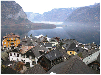 Wie links aber leicht geschwenkte Ansicht,
2005.
Wie links aber leicht geschwenkte Ansicht,
2005.
 Wie oben, aber 2007.
 Wie oben, aber 2007.
.
 Wie die beiden Fotos oben, aber 2010.
Blick auf das Zentrum der kleinen mittelalterlichen Stadt und den See.
Das Foto ist von den Parkplatz-Terrassen aus aufgenommen, die vor
wenigen Jahrzehnten gebaut wurden.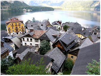 Wie die beiden Fotos oben,
aber 2010.
Wie die beiden Fotos oben,
aber 2010.
Blick auf den südlichsten Teil des Hallstätter Sees.
Der Ort Hallstatt, der in
der Dachstein-Gebirgsregion der österreichischen Alpen gelegen ist, ist
Teil des UNESCO-Weltkulturerbes. Diese Region wird hier als
„Hallstatt-Dachstein
Salzkammergut Kulturlandschaft“ bezeichnet. Eine
detaillierte anschauliche Beschreibung dieses Standortes zusammen
mit den sieben übrigen Welterbestätten in Österreich ist in
Linder
& Dröscher
(2007, R)
ausgeführt.
Rückblick aus dem Jahr 2013 auf
frühere SeenUntersuchungen: Der Hallstätter See hat das Interesse
der Wissenschaftler seit mehr als
160 Jahre angezogen.
we look back at the lake in year 2013:
lake hallstaetter see has attracted lake scientists for more than 160
years
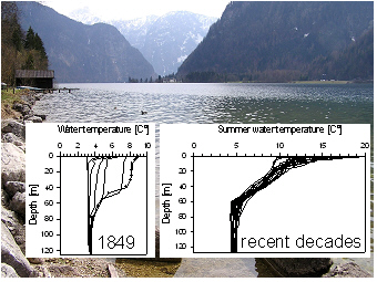 Hallstätter See, 2005:
Links eingefügte Grafik - Tiefenprofile der Wassertemperatur im Jahre
1849 gemessen und veröffentlicht von Simony (1850). Die Linie mit
den Datenpunkten zeigt die Messdaten für den 31. August 1849. Die
anderen
Linien sind Messungen vom April, Mai und November desselben Jahres.
Rechts eingefügte Grafik - wie links, aber in den
letzten Jahrzehnten gemessen. Es werden hier nur die Werte für den
Sommer (Juli, August) gezeigt (Sommerdaten vom 'Bundesamt für
Gewässerökologie,
Fischereibiologie und Seenkunde').There
is hardly any other lake in the
Salzkammergut district that attracted naturalists for more than 160.
Early studies in Hallstätter See were mainly based on the temperature
depth profiles, and hence introduced limnological research in the
alpine region and in Austria. Probably, the most popular publication of
early measurements is by
Friedrich Simony released in 1850 and was
entitled ‘Die Seen des Salzkammergutes’ (‘The lakes of the
Salzkammergut district’). Grims (1996) describes Simony as a
naturalist, who was focused on land surveying of alpine mountains and
of
lake basins, but had also broad interests on glaciers, climatic ice
age, mineralogy & geology and botany & zoology.
Simony used a minimum
thermometer developed by Kapeller to measure
water temperature along vertical depths in the alpine lakes in the
Salzkammergut district (Simony, 1850). He wrote that eight minutes were
sufficient
enough for the thermal adjustment of the thermometer in the depth to
measure reliable data. According to his description, the replicated
measurements varied in the narrow range of 0.05 °C only. The
temperature
profiles of Hallstätter See by Simony are drawn in the left inset of
the right photo. The graph for summer measured on the date on
August 31
in 1849 is marked by plotting the individual data points, difficult to
confuse with lines of the other measurements in April, May and November
in 1849. This summer depth profile illustrates well that only the upper
stratum of the lake, the layer of about 40 (to 60) m is warmed up in
summer. This phenomenon of thermal
stratification is common in deep
lakes but was rather unknown at that time. With increasing air
temperature from spring to summer, the lake heats up successively from
the surface to deeper layers. This includes that (1) surface water of
the lake is getting warmer, (2) the thickness of the warmed up surface
layer increases consecutively (3) the thermocline 'grows up' and moves
downward into deeper layers (4) and the resistance against vertical
mixing increases (thermal stability of water column increases).
According to these thermal gradients, the water body of a deep lake
reaches a stabile thermal stratification in late summer. Further
descriptions about the thermocline, the metalinmion and the thermal
stability of water bodies is presented in the section ‘annual cycles by
heating and cooling of the water body’ on the website about lake
Mondsee S, and in the
section ‘Ammersee and Mondsee: two lakes but one
story’ on the website about lake Ammersee S. It
is worth
mentioning here,
that the thermal gradients in Hallstaetter See are partly interfered
with by
a stronger salinity gradient promoting a particular type of mixing, the
meromixis as it will be described under the section below.
Looking at recent temperature depth profiles for July and August
fromthe seventies to nineties shown in the right inset, it reminds us
that
the summer water surface
temperature may vary a lot among years in
Hallstaetter See. These summer temperature records ranged at the near
surface of 2 m from 9.7 to 18.5 °C and at depth of 9.5m from
9.5 to
13.15. The individual measurements on August 31 in 1949 by
Simony at
2 and 9.5 m refer to a bit lower temperatures, namely to 9 and
7.3 °C
respectively. Taking into account the different equipment that was used
about 160 years ago, the temperature records by Simony should be
interpreted with caution when compared with recent temperature data
sets. Besides this uncertainty, however, one may say that Simony has
just measured in a year of a particularly cold summer. Others might
claim that warming by climate change might be most responsible that the
temperature measured by Simony is rather an outlier than within the
range of statistical deviation from the expectation when compared with
recent times.
According to monthly means of surface temperature in August, measured
in Hallstatt, the temperature tended indeed to increase by about 1.326
degree over a period of 100 years (1901-2000), namely from 14.9 °C to
15.74. During this period, in 54 years occurred a negative
anomaly in August, which was on average –1.15 °C. In the remaining 46
years, a positive temperature anomaly was recorded and here the mean
temperature in August was on average 1.38 °C warmer than expected by
the
long-term trend. In extreme years, the surface temperature in August
could be even 3.28°C lower or 4.16 higher, respectively. These few
numbers illustrate the range of temperature variation in August in
individual years during the 20th century. It shows that the
measurements by Simony are not that extreme as at first glance they
might have seemed when comparing the temperature depth profiles of both
discussed graphs. Climate warming, however, does not follow necessarily
linear trends over too long periods and therefore, the trend estimated
for the 20th century cannot be simply used to calculate backwards what
the usual temperature in August 1849 would have been. For this reason,
the question is not yet answered here to what extent climate warming or
an extreme cold summer or simply the uncertainty caused by the use of
different instruments was most responsible that Friedrich Simony had
written in his notes the numbers of a relatively cold-water body in
August 1849. The climate
response on the WHOLE water body of Hallstaetter See will not
be described on this page.
Evidence for significant
DEEPWATER warming at depths of 80, 100 and
120m in Hallstaetter See, however, was found in a recent study (Table
2 and Fig.2 I
in Dokulil et al.
2006 R).
These statistically significant
trends in Hallstaetter See were in concert with other lakes of the
Salzkammergut district and also lakes across Europe. Other deep alpine
lakes in Austria, however, seemed to respond more closely to global
climate signals than Hallstaetter See (see the correlation with the
NAO-index
integrated
over the period January to May in Table
4
and Fig.3 in Dokulil et al.
2006 R;
NAO signal see also Mondsee S
and Ammersee S). The reason for
the individual lake response of Hallstaetter See can be attributed to
the low wind-exposure of the alpine valley lake basin, which extends
from north
to south (see page 2789 in
Dokulil et al.
2006 R).
It is further argued, that
Hallstätter See is locally surrounded by a cold environment as the lake
receives on average about five hours less sunshine than other alpine
lakes in it’s neighbourhood. This situation thus counterbalances the
impact of global warming and explains why the significant increase of
deepwater warming is not that strong compared to other neighbouring
lakes
(e.g. see for lake Traunsee Table 2
and Fig.2 J in Dokulil et al.
2006 R).
Another reason for the individual lake response to climate signals can
be found when considering the study by Ficker et al. (2011 R),
even the
impact of climate was not mentioned in their analysis. They observed
two water-mixing regimes that occurred alternatively from time to time
in recent decades in Hallstaetter See, the meromixis and holomixis. The
shifts among the both mixing regimes were linked to the many ups and
downs of water density in the salt-mining lake, namely by the sudden
increase of chloride concentrations after every brine spill, on the one
hand, and a decrease by washing-out on the other (Fig.2
in Ficker et al.
2011 R).
While periods of high chloride were associated with
meromictic mixing, periods below a certain threshold concentrations of
chloride referred to holomixictic mixing. The toggled two mixing
regimes that were mainly linked to fluctuations of chloride
concentration (and not primarily to temperature effects) might thus
also explain the more individual
lake response to climate signals (NAO)
in Hallstaetter See than compared with other deep alpine
lakes.
Two studies - by Liburnau (1898) mainly about zooplankton
and by
Keissler (1903) about phyto- and zooplankton
– describe very early the
planktonic species in lake Hallstaetter See. Keissler used an Apstein
plankton net to take samples, and hence he describes only large or
colonial phytoplankton
species as e.g. the green algae Staurastrum
paradoxum, Sphaerocystis
schroeteri and Botryococcus
braunii, the diatoms Cyclotella
comta and Asterionella
formosa, the chrysophyte Dinobryon
divergens and
the dinoflagellates Ceratium
hirundinella and Peridinium
cinctum. The size
of these phytoplankton forms is larger than (30 -) 50µm. Large species
are, however, usually much less abundant in alpine lakes than small
species. It could be shown for other alpine lakes in Austria and in
Switzerland, that the
small cell size
fraction of only 0-10 µm contributes
more than 50% to the total chlorophyll concentration of
phytoplankton
(Teubner et al. 2001 R).
In this way, the samples by Keissler certainly
missed main components of phytoplankton. Despite these uncertainties,
Kreissler is probably right to emphasize that the abundance of the
species found in net phytoplankton from Hallstaetter See was in
particular low when compared with those of other lakes in the
Salzkammergut district. He also stated that phytoplankton was only
found in the upper 60 meters, which corresponds to the warmed up top
layer described by Simony. Taking depth integrated net samples,
Keissler also measured the water transparency (see details in the
section below).
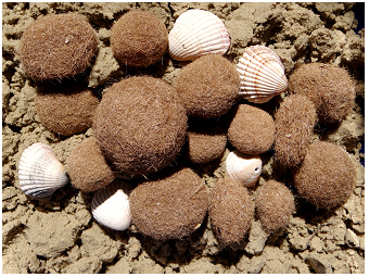 Meeresbälle,
2013:
Meeresbälle,
2013:
Aus Fasern gebildete Meereskugeln sowie Muscheln am Strand des
Mittelmeeres. Die Form und das Aussehen dieser Bälle ähnelt den Kugeln,
die im See Hallstätter See gefunden werden. Sie werden hier nach Morton
als “Die Hallstätter Seekugeln“ oder “Lärchennadel-Bälle“
benannt.
Solche Seekugeln wurden auch von anderen Seen in Österreich
beschrieben. 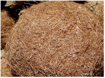 Meeresbälle, 2013:
Wie das Foto links, aber als Detailansicht. Diese Kugeln vom Meer
schauen weniger grob gefasert aus als die der Seen, die durch Nadeln
aufgebaut sind.
The fibrous spherical to ellipsoid formations found in the
littoral zone and on the shore of Hallstätter See are perhaps the
greatest
curiosities for people enjoying nature and lakes, and were described
first for Hallstaetter See by Friedrich Morton. He called these
fibre-lake-balls ‘Die
Hallstätter Seekugeln‘
('The lake balls from
Hallstaetter See', Morton, 1924 R
R),
and in a later publication
‘Lärchennadelnbälle’
(‘Balls made by larch needles’). These balls are
processed from needles of Larix
decidua. Morton wrote that he found
them most abundant in shallow shore areas of Hallstätter See, where the
needles built a dense layer of about 10 centimetres on littoral
sediment washed on the waves. The intertwining of plant fibres of Larix
needles begins on small pieces of rhizomes e.g. of Carex from
the
littoral or other material of rough surface. The initial small balls
grow up further in the moved shallow water. According to Morton, these
balls were common on the south-east shore of the lake, between the
inlet of River Obertraun and the village Winkl; and were also found but
more rare along the west shore between ‘Lahn und dem Landungsplatze im
Markte’. These natural fibre marbles actually might have fascinated
him, as he published a series of seven (!) short notes on
‘Lärchennadelbälle’ found in Hallstätter See (the first was published
in 1934, see all references in Müller & Werth, 1982 R)
and one publication for a lake nearby, the
Offensee (balls
were found close to the outlet of stream Offenbach; Morton, 1964
R).
Such fibrous balls (‘Seebälle / Meeresbälle’ ; ‘sea balls /
marine balls’) seem to be more common in the Mediterranean Sea than in
lakes (see the two photos above). Sea
balls are built by other plant
fibres than Larch needles, but look very like the lake balls, which
are shown in photos published by Morton 1964 R.
anzeichen einer ökologischen
unstimmigkeit in diesem salzhaltigen see: Ist das kristallklare Wasser des Hallstätter
Sees tatsächlich ein Ausdruck eines gesunden Ökosystems?
the gap in this saline aquatic
ecosystem: is the crystal-clear water
of Hallstaetter See indeed the signature for a healthy
environment?
 Hallstätter See, 2005:
Das kristallklare Wasser verspricht auf den ersten Blick eine hohe
Wasserqualität dieses Alpensees: Zeigt es hier zugleich
den Status
eines uneingeschränkt gesunden Ökosystems an?
One may argue that water transparency
is the
best parameter describing water quality of inland waters. According to
Keissler (1903), the Apstein plankton net was visible up to 3 to
6 m
below the water surface during
sampling from July to September 1902 in Hallstaetter See (the average
was 4 m, 12 measurements). The standard
measurement with a Secchi disk (see preface S) in
recent
decades
revealed a
Secchi transparency depth of about 4 to 5 m in
June and
August in this lake, respectively (ranging from 1.5 to 7 m,
see
Fig.8 in Dokulil
& Teubner
2002 R). The water
transparency depends mainly on the amount of
floating particles in the water column, which are described as
inorganic and organic suspended solids. The latter are mainly phyto-
and zooplankton that are most abundant during growing season (see
seasonal development of phytoplankton on the page about
Bergknappweiher S).
When Secchi depth is measured in winter or before the
spring peak development, the values can be even higher. In the case of
Hallstaetter See the Secchi depth is early spring about 8 m, ranging
from 7-10 m (see data for March in Fig.
8 in Dokulil
& Teubner
2002 R).
Such
crystal-clear water, as found in Hallstaetter See, seems to be very
attractive for tourists to visit and enjoy the alpine lake region. Only
in few lakes in the Salzkammergut district, as e.g in lake Attersee S
(see Fig. 8 in Dokulil
& Teubner
2002 R)
is the water transparency even higher
than in Hallstaetter See.
 Das Ostufer vom Hallstätter See,
2005:
Das Ostufer vom Hallstätter See,
2005:
Der beliebte Wanderweg “Ostuferweg“ geht durch Wiesen, Obstgärten und
Wälder entlang dem Seeufer.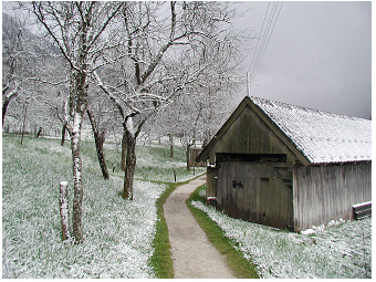 Das Ostufer vom Hallstätter
See, 2001:
Das Ostufer vom Hallstätter
See, 2001:
Streuobstwiese mit frisch gefallenem Schnee zu Ostern (April) am
Seeufer. Rechtsseitig ist ein Bootshaus zu sehen.
 Das Ostufer vom Hallstätter See,
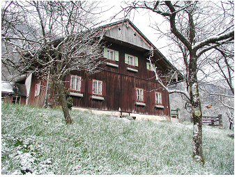
2001:
Das Ostufer vom Hallstätter See,
2001:
Traditionelle alpine Holzhäuser von Streuobstwiesen umgeben liegen nahe
der Wasserkante vom Seeufer.
 Das Ostufer vom Hallstätter See,
2000.
Das Ostufer vom Hallstätter See,
2000.
Blühende Sommerwiese mit Glatthafer (Arrhenatherum
elatius)
und Habichtskraut (Crepis
spec.) unweit vom Seeufer.
 Das Ostufer vom Hallstätter See,
2005.
Das Ostufer vom Hallstätter See,
2005.
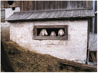
Nachhaltige Tierhaltung auf kleinen Bauernhöfen befindet sich am Ufer
von diesem Alpensee.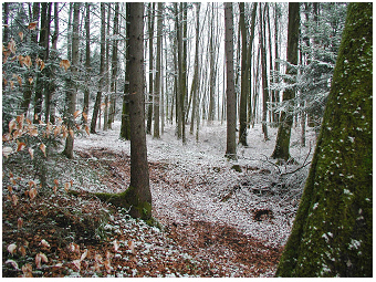 Das Ostufer vom Hallstätter
See,
2001.
Das Ostufer vom Hallstätter
See,
2001.
Wälder aus Buchen (Fagus sylvatica)
und Fichten (Picea
abies)
erstrecken sich entlang dieses Alpensees.
In view of biota living in the lake water body, water
transparency refers to the underwater
light climate that controls the
growth of microbial primary producers (e.g. algae). The Secchi depth of
about 4.5 m in summer and 8 m in early spring in Hallstaetter See
corresponds to an euphotic
depth covering about the top 15 and 27 m,
respectively (see also underwater light climate described on the page
for Mondsee S
and Traunsee S). The epilimnetic
layer (see depth profiles for summer
water temperature shown in the figure above) might thus largely exceed
the euphotic layer. The proportion between the concentration of
chlorophyll-a (Chl-a), which is used as a rough estimator for biovolume
of phytoplankton, and the concentration of total phosphorus (TP) in
Hallstaetter See, is relative low when compared with the Chl-a:TP
proportion in other alpine lakes of the Salzkammergut district, like
Attersee, Mondsee, Traunsee and Wolfgangsee (see Fig. 6.54
in Dokulil
et al. 2000). In other words: It seems that the
phytoplankton yield is
much less than might be expected from the total phosphorus pool size
in Hallstaetter See (see also Fig.
8 in Dokulil
& Teubner
2002 R).
Even though the
water looks crystal-clear the surprisingly low phytoplankton biomass
raises questions about the ecosystem integrity or the
ecosystem
health. One reason among others could be perhaps the mismatch
between
the euphotic depth and mixing depth described for this
lake before.
Another impact might be due to the large discharge by the River Traun,
which is passing the lake Hallstaetter See (see the plume horizon of
the River Traun identified in the top
6.5 to 20 m along the 140 m depth
profile in Traunsee S).
Salinity, however, might not simply explain the unexpected low
biovolume of phytoplankton as values for conductivity and chloride are
much lower in lake Hallstaetter See than in lake Traunsee. Further, the
low nutrient concentration, in particular of phosphorus, would not
contribute to understanding the low phytoplankton development in
Hallstaetter See, as phosphorus concentration in Attersee is even much
lower than in Hallstaetter See but the amount of phytoplankton
biovolume relative to the total phosphorus pool is commonly higher in
Attersee than in Hallstaetter See. As lake Attersee S
is an
ultra-oligotrophic lake and as the lake was not used for salt mining at
all, phytoplankton assemblages of this lake occur in a pristine alpine
ecosystem. In view of the
European Water Framework Directive lake
Attersee is thus described as reference ecosystem for the Austrian
alpine lakes in the Salzkammergut district. For many reasons, however,
coarse and simple monitoring measurements in Hallstaetter See in
comparison to other mentioned alpine neighbouring lakes, that strictly
satisfy the rules of European Water Framework Directive, do not provide
a satisfying perspective to understand the complexity or functioning of
these ecosystems. A subtler approach, however, seems to be more
appropriate to
answer the question of unexpected low biomass of
primary producers in Hallstaetter See. An advanced
ecosystem study might
cover the utilization and turnover of nutrients (in
particular of phosphorus, see small
scale phosphate acquisition on the page
preface S), the
potential growth inhibition of biota and
the match or mismatch of allocation pattern among various planktonic
organisms - bacteria, cyanobacteria, algae and the many types of
zooplankton -, and also fish. Such a more detailed study about the
interaction of aquatic organisms with their environment along depth
layers
would be
essential to answer the question how efficiently nutrients can be
exploited by biota in Hallstaetter See.
 >
>