geographische lage des baches
 Shennong Strom, 2004:
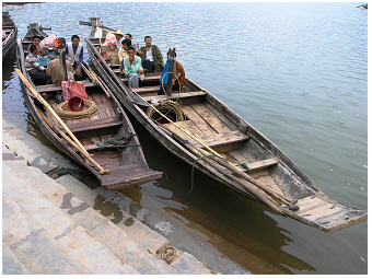
Ein typisches Stimmungsbild vom Strom – leise gleiten kleine
traditionell-chinesische Holz-Planken-Boote ('sam pans') den Strom
entlang. Das
gleichmäßig-ruhige Plätschern durch das rhythmische Bewegen der Ruder
und Stakstangen ist kaum zu hören. Diese kleinen Boote
werden umgangssprachlich auch als "peapod boat", d.h.
als "Erbsenschale" oder "Erbsenhülse" bezeichnet. 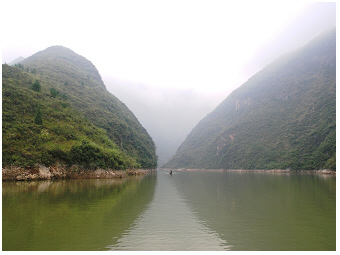 Shennong Strom, 2004:
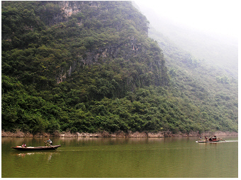
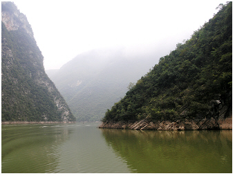
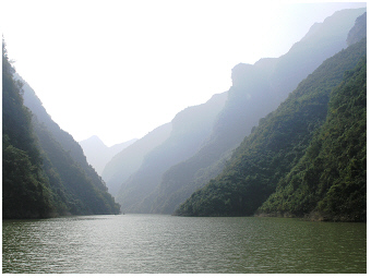
Ein typischer Landschaftsblick vom Strom nahe seiner Mündung
in den Jangtsekiang - der Strom schlängelt sich im Tal zwischen
abgerundeten Bergkappen entlang. Das Wasser sieht gelblich-grün gefärbt
aus. Die Wasserfarbe ergibt sich nicht etwa durch die Wasserspiegelung
der angrenzenden grün-bewaldeten Berghänge, sondern resultiert primär
aus den vermehrt auftretenden photosynthetischen Mikroorganismen im
Wasserkörper, wie z.B. den Algen.
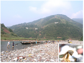
Der Shennong Fluss (Shen Nong Xi, Shen Nong Fluss) ist ein
Nebenfluss vom Jangtsekiang.
Die Mündung dieses Gebirgsstroms liegt in der Nähe der Stadt Badong (31°02’
N 110°20’ E)
381 m über dem Meeresspiegel, in der Enshi Tujia
und Miao Autonomen Präfektur der Provinz Hubei. Der Shennong Fluss ist
etwa 60 km lang. Im Jahr des Besuches, 2004, machte der
schiffbare Teil
etwa ein Drittel der Länge des Gebirgsstroms aus. Die malerische
Landschaft,
die Relikte historischer Besiedlungen (z.B. die in den Felsenspalten
hoch oben
hängenden Särge) und die gegenwärtige Tradition der an diesem Fluss
lebenden Menschen stellen den Shennong als eine Attraktion für
Touristen aus dem In- und Ausland heraus (siehe Galeriefoto 9).
Besucher, die den Shennong Fluss entlang fahren, müssen in kleinere
Motor-Ausflugsschiffe umsteigen, weil die riesigen Jangtsekiang
Kreuzfahrtschiffe das schmale Shennong Bachbett nicht
passieren können. Die kleineren Ausflugsschiffe fahren
den Strom etwa 20 km von der Mündung weg in eine
Gebirgslandschaft
hinein.
In einem kleinen Hafen, der am Ende des schiffbaren
Abschnittes
liegt,
wechseln dann die Reisenden von dem Schiff auf kleine Boote. Die
Bevölkerung vor Ort bietet hier nämlich an, den Gebirgsstrom
weiter
flussaufwärts mit traditionellen, flachen Holzbooten befahren
zu
können. Diese Boote werden zuerst rudernd bewegt, später stakend oder
sogar treidelnd durch das sich weiter verengende und auch zunehmend
flachere Gebirgsbachbett (siehe Galeriefotos
12 und 13).
Mit dem Bau des Drei-Schluchten-Staudammes
war im Jahr 2004 der Wasserspiegel
im Jangtsekiang
S
und damit auch in seinen von dem Damm
flussaufwärts
gelegenen Nebenflüssen bereits um einige Meter angehoben worden. Die
Wasserstandsmarkierungen, die am Jangtsekiang zeitgleich mit dem Besuch
am Shennong Xi fotografiert wurden, zeigen an, dass der Wasserstand mit
der Fertigstellung des Dammes um weitere 70 Meter steigen soll. Viele
auf dieser Shennong Xi Webseite gezeigten Uferstellen werden damit
heute
in
der Form
nicht mehr existieren und unter der Wasserlinie liegend dauerhaft
geflutet sein.
Auf dieser Webseite wird der schiffbare Abschnitt von
etwa 20
km (10 bis 20 km?) in der Nähe der Mündung in den Jangtsekiang Fluss
sowie eine weitere kurze Strecke von dem eigentlich schmalen
Gebirgsbach beschrieben. Anders als das gelb-braun erdige Wasser vom
Jangtsekiang ist das Wasser des schiffbaren Abschnittes vom Shennong
aufgrund einer recht massiven Phytoplanktonentwicklung
intensiv gelblich grün
gefärbt. Stromaufwärts von der Stadt mit dem kleinen Hafen geht der
Strom in einen schmalen kristallklaren
Gebirgsbach über. Der sich
ändernde Charakter dieses
Stromes – nämlich der Wechsel von einem klaren steinigen
Gebirgsbach im
Oberlauf zu einem algen-grünen schiffbaren Strom nahe der Mündung –
wird detaillierter in dem nachfolgenden Text beschrieben.
the changing nature along the downward
flow of the stream:
the different faces of shennong xi.
The words of the idiom
‘panta rhei’ refer to the flow of a river (in German
‘Alles fliesst/Alles ist im Fluss’) with the meaning that ‘everything
changes' or 'everything is in progress’. Indeed, ecosystem changes can
be identified
along the downward
flow of a river channel: from the mountain highland
to the mouth, where the stream joins into a larger stream
or river or
into a lake or ocean. As the landscape changes adjacent to the stream,
also the character of the streambed, the oxygen concentration,
temperature, flow velocity, turbidity and nutrient level alter.
Further, in accordance to this changing environment, the habitat
conditions and hence adjusted biotic communities alter successively. In
contrast to floating microorganisms, which are
mainly passively drifted with the downward flow, larger animals can
move and therefore, stay in a certain stretch preferred to live. Key
species of fish communities are thus commonly used to describe
particular zones of habitat conditions of a stream (zonation of
a
stream). Ecologists are describing the complexity of
biotic life in a
river system and the connected floodplain by a numerous of concepts,
which are not explained at all here. As the main focus of the
lakeriver-website
is on algae in water basins, the zonation of the Shennong stream will
be only discussed with respect to the water color and the development
of phytoplankton, i.e. in the water floating or drifting photosynthetic
micoorganisms.
 Gebirgsstrom Shennong,
2004:
Gebirgsstrom Shennong,
2004:
Das Wasser sieht kristallklar aus.
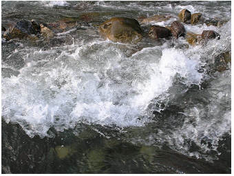 Gebirgsstrom Shennong, 2004:
Stromschnellen im flachen steinigen Bachbett.
 Gebirgsstrom Shennong,
2004:
Gebirgsstrom Shennong,
2004:
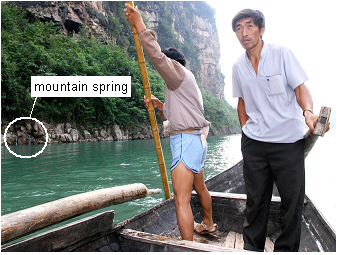
Weiter stromaufwärts prägen steile Felswände und
Gebirgsquellen ('mountain springs') das Bild vom Bachbett. Die
türkis-blaugrüne Farbe
ergibt sich allein durch die optischen Eigenschaften des Wassers und
nicht durch Mikroorganismen wie Algen in eutrophierten, d.h.
nährstoffreichen, Gewässern (siehe auch den tief türkis gefärbten
Wasserkörper im alpinen Traunsee S
auf dieser lakeriver-Webseite).
 Gebirgsstrom Shennong, 2004:
Detailansicht auf die felsigen Hänge am Bach.
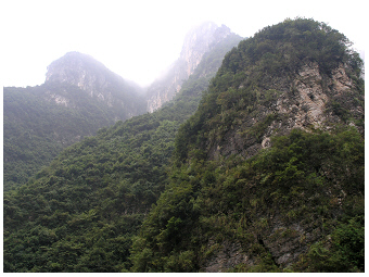
The four photos above are from the highland mountain
stretch
of the Shennong stream. The water tumbled over rocks and stones of a
shallow river bed and looked crystal clear. Mountain
springs could be
commonly seen on the rocky shore. At steeper holes, the deep
water
looked turquoise-blue. This colour was just due to optical
properties of
the water, not due to ‘blue-green algae’, the cyanobacteria. Another
water basin with deep-turquoise coloured water described on the
lakeriver-website
is the
alpine lake Traunsee S in the
Austrian Alps. In that oligotrophic, i.e.
nutrient-poor lake, the
rather blue-milky water colour is also not due to phytoplankton, but
due
to
suspended solids from the mountains.
Primary producers, such as planktonic
algae and cyanobacteria, cannot grow well in
the rapidly flowing headwater
for many reasons. Due to the strong current running, the growth of
cells of primary producers is inhibited by mechanical stress.
Furthermore,
the nutrients needed for phytoplankton growth are insufficiently
available in the headwater. The bordering landscapes are rocks where no
or only a thin layer of soil is on the surface. Thus, after rainfall,
the water does NOT receive larger amounts of nutrients simply by soil
erosion. Moreover, the steep rocky slopes at the headwater seemed to be
unsuitable, not a favourite place for housing and farming at the
Shennong stream. Accordingly, the anthropogenic impact of a nutrient
increase
played certainly no role on this stretch. The stony
stream bed and biota
found there are illustrated in the photos below.
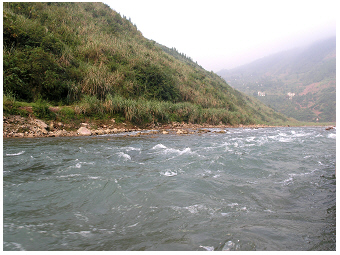
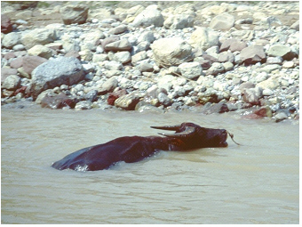 Gebirgsfluss Shennong,
1997:
Gebirgsfluss Shennong,
1997:
Dieses Foto wurde als einziges aus einer Fotoserie von diesem Strom aus
den späten neunziger Jahren ausgewählt. Bevor der Wasserstand mit dem
Bau des Drei-Schluchten-Dammes angehoben wurde, sah man häufig solch
eine
Fluss-Szene: Ein Bauern lässt hier seinen Wasserbüffel im seichten Ufer
baden. Gebirgsfluss Shennong,
2004:
Gebirgsfluss Shennong,
2004:
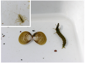
Steine in verschiedenen Größen wurden auf den flachen Ufern dieses
Gebirgsbach gefunden. Das Bachbett ist Lebensraum für viele Tiere, wie
z.B. für Vertreter vom Makrozoobenthos. Nach dem Hochheben der Steine
sind diese Tiere leicht zu entdecken.
 Gebirgsfluss Shennong,
2004:
Gebirgsfluss Shennong,
2004:
Studentische Exkursion der Universität Wien, die von chinesischen
Kollegen organisiert wurde: Probenahme im seichten Bachbett und auf den
Schotterbänken. Eingefügtes Detailfoto: Kopf des Insekts Miomantis. Das Insekt
wurde auf den Steinen am Ufer gefunden.
 Gebirgsfluss Shennong, 2004:
Die Tiere, die das steinige Bachbett hier besiedeln, sind z.B. Larven
von Insekten und Muscheln (Corbicula
flumine). Während der
Studentenexkursion wurden sämtliche Tiere lebend gesammelt und nach der
taxonomischen
Bestimmung vor Ort sofort wieder an ihrem Fundort ausgesetzt.
 Gebirgsfluss Shennong,
2004:
Gebirgsfluss Shennong,
2004:
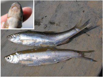
Fische an diesem flachen und steinigen Bachabschnitt.
 Gebirgsfluss Shennong,
2004:
Gebirgsfluss Shennong,
2004:
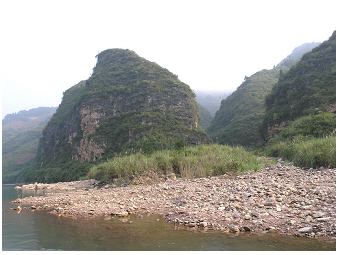
Weitflächige Schotterbänke sind stromaufwärts an flachen Uferstrecken
dieses Gebirgsbaches verbreitet. Die Bauarbeiten des
Drei-Schluchten-Staudammes waren in jener Zeit zugange. Mit der
Fertigstellung des Dammes werden diese flachen Stromstrecken dauerhaft
geflutet sein (siehe Details im obersten Textabschnitt).
Going further downward with the flow, the current is reduced and
thewater meanders across valleys of less steep slope. In the case of
the
Shennong stream, the stream became wider and deeper at a larger town or
city, the place where the habour for cruise ships was as the navigable
stretch ended here at that time of the visit in 2004. Both, the lower
current by meandering (longer retention time of water in a stretch) and
the increase of nutrients (loaded from the bordering landscape) support
in general the growth of
phytoplankton in a stream. While a stream
turns from a headwater to a downstream stretch, drifting algae still
live on the ‘edge’. The water looks yet almost crystal-clear due to the
lack of mass development of phytoplankton. The aspects of the limited
development of phytoplankton near the headwater will be discussed in
greater detail in the following paragraph.
In stretches of turbulent water flow, floating photosynthetic
microorganisms can only grow in shore areas separated from the main
stream, i.e. in niches such as small bays and cavities, where algae are
not rapidly washed out. The retained algae in such small niches need to
utilize nutrients. These nutrients, mainly compounds of phosphorus and
nitrogen, are replenished naturally from the geological background,
e.g. by soil erosion from the bordering valleys - or in the case of
Shennong Xi also from farm land. Algae then grow, i.e. they accomplish
at least one cell division. In case the
rate of cell division is higher
than the washing out rate, and grazing does not reduce
algal biomass
afterward, the phytoplankton organisms can succeed over several days to
a few weeks. The phytoplankton of such niches becomes introduced to the
main stream channel only by elevated water level, e.g. after flood
events such as heavy rainfalls. In case the demand for nutrients by
algae is higher than the supply/replenishment from the environment, the
algal growth becomes controlled by nutrients. This situation of low
nutrient load is typically found when rocks rather than
valleys and
soil are covering the stream bank, and no farmland is bordering the
stream. Under such nutrient-limiting
growth conditions, algae usually
need much more time to accomplish cell division and thus to increase
their biomass compared to an unlimited growth in nutrient-rich waters
much further downstream. The scenario of the growth of non-attached
algae in a stream (some forms of other algae are attached to stones in
the streambed, what are not considered here at all) is herewith just
described in a simplified form. It might give a rough idea about
phytoplankton development in a headwater that goes over into a
downstream stretch. The mutual
adjustment of algae and their
environment (other biota, physical and chemical
conditions), which
implies that algae are enabled to respond rapidly to environmental
modifications, however, is more complex and actually matches rather the
life in nature than the paraphrased description before.
Going further downstream, the deeper and wider streambed
increasesconsiderably the retention time of the water, and the stream
receives
usually more nutrients from tributaries and bordering landscape than
upstream. Reduced flow and an
enhanced nutrient availability allow
algae to accomplish cell division and thus to achieve growth while
drifting in the stream channel. Actually, in view of
phytoplankton
growth, this stretch might remember a ‘steady-state flow’ as known from
algal growth experiments in the lab. The increased biomass of floating
photosynthetic microorganisms colours the water yellow-green as indeed
seen on most photos of the navigable stretch across the Shennong
stream. The photos 1-3 and 6-7 in
the gallery, the two photos shown in
the section about the geographical location and the two photos below
indicate this green colour caused by phytoplankton. Even the water
transparency is reduced due to the floating algae; sufficient light for
photosynthesis penetrates the channel at least at a wider surface layer
of the stream. In particular, species that can adjust to low light
intensities in a turbulent water body, grow well (see adjustment of
photosynthesis described for phytoplankton in alpine lake Traunsee, S
on
the lakeriver-website). Depending on the water retention time, it is
not only
the watercolour and the phytoplankton composition but also the whole
ecosystem that changes. With increasing retention time of water, the
ecosystem of a river turns to a riverine lake and finally to a lake as
described for lake
Grosser Mueggelsee, S
on the lakeriver-website.
 Shennong Fluss, 2004:
Schiffbarer Abschnitt stromabwärts, aber mit noch recht
steilen, felsigen
Uferhängen. Die Felsen sind von einer natürlichen Gebirgsvegetation mit
Bäumen und
Sträuchern bedeckt. Das Wasser sieht grün gefärbt aus.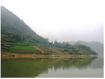 Shennong Fluss, 2004:
Dieser Stromabschnitt liegt bereits sehr nahe der Mündung in den
Jangtsekiang. Bauern bewirtschaften hier die Ufer bis zur Wasserkante
hinunter. Zum Teil sind terrassierte Felder angelegt. Das Wasser sieht
grün-bräunlich gefärbt aus. Eine suspendierte Partikelmischung liegt im
Wasser vor, nämlich aus eingeschwemmtem Bodenerosionsmaterial und sich
im Wasser vermehrenden Algen.
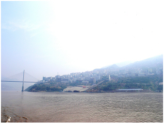 Jangtsekiang und
Badong, 2004:
Jangtsekiang und
Badong, 2004:
Die Stadt Badong liegt am Jangtsekiang Fluss, nahe der Mündung vom
Shennong Strom. Typischerweise sieht dieses Flusswasser allein
bräunlich
gefärbt
aus. Eine stärkere Algenentwicklung bleibt hier aufgrund der
Wachstumshemmung im Fluss aus, was im Text näher beschrieben
wird.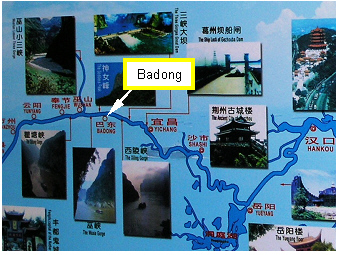 Die Touristenkarte zeigt
die Attraktionen
und Städte in der Flussebene vom
Jangtsekiang. Sie war auf einem Kreuzfahrtschiff 2004 ausgehangen.
Die Touristenkarte zeigt
die Attraktionen
und Städte in der Flussebene vom
Jangtsekiang. Sie war auf einem Kreuzfahrtschiff 2004 ausgehangen.
Close to the mouth
into the Yangtze River, the water of
Shennong Xi looks brownish green due to enhanced concentrations of
suspended solids (silt) in addition to floating green cells of primary
producers. The muddy water colour is due to soil erosion from the
bordering landscape, here often used for farming (see photo above,
taken at city Badong).
The crops are grown on the slopes on Shennong Xi even close down to the
water's edge, in some areas on terraced fields. The same was found for
the Yangtze River S, where the water
colour looks just brown without
a greenish tone.
The muddy water is nutrient rich and hence might support algal
growth.
Furthermore, water current is reduced in wider streambeds, which in
addition might promote phytoplankton development. The low transparency
of the water, however, provides insufficient light for
photosynthesis. Thus, the
huge amount of nutrient has, in principle,
the enormous potential for an algal bloom, but cannot be utilized by
algae drifting in the muddy stream or river. The dissolved
nutrients
are accumulated in the water while transferred further downstream.
Entering a broad basin as a lake or a reservoir, the suspended solids
of the river water deposit rapidly to the bottom (sediment layer) and
thus the water transparency significantly increases. This scenario of
improved underwater light climate allows phytoplankton growth. Within a
few days, the water colour changes to green as one cell
division per
day (daily growth rate = 0.693 d-1), i.e. the
doubling of phytoplankton biomass per day, can be easily
accomplished
during an initial nutrient-unlimited growth phase even in a
natural habitat (algal growth rates of nutrient-addition experiments in
the lab can be much
higher). Planktonic blooms of cyanobacteria in lakes, which
were mainly due to nutrient-rich inflows (!) are described on the
lakeriver-website for a number of shallow water basins such as the
lakes lake Taihu S, Dianchi S and
Grosser Mueggelsee S. In the Meiliang
Bay of the north of lake Taihu,
were two tributaries join into the
lake, the algal biomass measured by chlorophyll-a
concentrations is
significantly higher than at the centre of Taihu (Fig.
5 in Chen et
al.
2003 R).
More interesting within the context stated before is, that
measurements of total phosphorus and also for total nitrogen close to
the mouth where the Lujiang
River joins into Meiliang Bay, were
statistically significant higher than at any sampling station in
Meiliang Bay or the centre of the lake (see map of sampling sites in
Fig.1 in Chen et
al.
2003 R). Despite the
nutrient-rich
situation of the inflow river water, the chlorophyll-a concentration is
lower than measured at the two sites in the bay (Bay 1 and B2) in the
close neighbourhood of this mouth (see annual averages for nutrients
and
chlorophyll-a at ‘M2’ for the mouth of Lujiang River and for the sites
‘B1&2’ in the Meiliang Bay Fig.2
in Chen et
al.
2003 R).
The enormous potential for an algal bloom by
nutrient-enrichment in the
river water became just obvious when
entering the large shallow basin of the lake bay. A scum of
cyanobacteria was built up during the growth season in the Meiliang Bay
in
Taihu.
take the chance going by boat upstream
shennong xi
 Gebirgsstrom Shennong,
2004:
Gebirgsstrom Shennong,
2004:
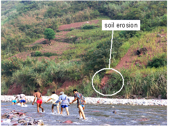
Männer (Treidler) ziehen die Boote stromaufwärts über einen flachen
Abschnitt eines erweiterten Bachbettes. Am steilen Uferhang sind
bestellte Felder zu sehen. Weiters ist Bodenerosion am Ufer auf dem
Foto zu erkennen. Sowohl die gängige Praxis der Bauern die Felder
hinunter bis zur Wasserkante zu bestellen und die frische Bodenerosion,
zeigen eine jüngste Flutung des Bachbettes an. Der Wasserstand erhöhte
sich zur damaligen Zeit sukzessive im Zuge der fortschreitenden
Fertigstellung des Drei-Schluchten-Dammes.
The photos of the Shennong stream shown on this website were mainly
taken in 2004, when the
Three Gorges Dam has been under
construction aimed at bringing up the water level to
175 m
(see the
water level mark the website about Yangtze
River S).
At that early
stage in 2004, the water level of Yangtze River had been already
increased by about 70m. The damming up of Yangtze River would also have
affected its tributaries: some old/ancient habitats have been
certainly lost, other
young habitats will be established with time. The elevation of the
water level
and water fluctuation definitely alters an ecosystem like the Shennon
Xi. In case of a scenario of further anthropogenic nutrient
enrichment, however, it might have a greater impact on such an
ecosystem.
As described in the introduction for Shennon Xi, the stretch
of the 'mountain stream' can only be passed by boat as in sections of a
stony streambed, the flow becomes shallow, while on other sections the
streambed is deep but very narrow. Local people were busy to organize
the tourist attraction of boat hauling or tugboat. The temperature
in an upstream section fed by springs is usually much lower than
upstream.
The visit
was in September, early autumn at Shennong Xi. People who were not
wading through the water, who were just waiting on the shore for
tourists or selling local goods were wearing long trousers. The
'boat haulers' or 'boat tuggers' preferred to wear long-sleeved shirts
due to the chilly
weather and cold water in the mountain stream.
 Gebirgsfluss Shennong,
2004:
Gebirgsfluss Shennong,
2004:
Flache Holzboote sind für das Treideln im flachen steinigen Flussbett
geeignet.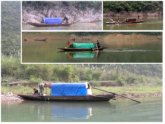 Gebirgsfluss Shennong,
2004:
Gebirgsfluss Shennong,
2004:
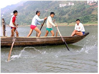
Ein Fischer kann sogar allein das Boot zugleich rudern und lenken: das
kurze seitliche Ruder dient der Vorwärtsbewegung und wird von der einen
Hand geführt, das längliche Ruder am Ende vom Boot dient der Steuerung
mit der anderen Hand.
 Gebirgsstrom Shennong,
2004:
Gebirgsstrom Shennong,
2004:
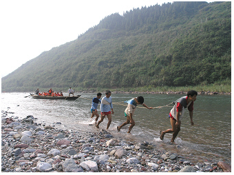
Männer schleppen (treideln) stromaufwärts die kleinen Boote mit
Touristen über eine flache Strecke des Bergbaches.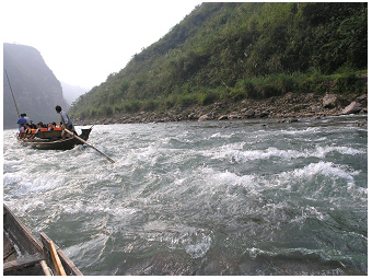 Gebirgsstrom Shennong, 2004:
Gleiche Stelle vom Bach wie auf dem Foto links, aber eine Bootsfahrt
stromabwärts.
 Gebirgsstrom Shennong,
2004:
Gebirgsstrom Shennong,
2004:
Wasserschöpfen aus dem flachen Boot mit Hilfe einer hölzernen
Wasserschaufel.
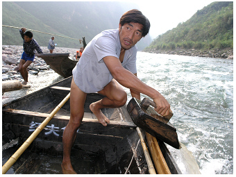
 Gebirgsstrom Shennong, 2004:
Detail der Konstruktion eines traditionellen Holzbootes zum Treideln
durch ein seichtes Bachbett. Der fest mit dem Bootsboden verankerte
kurze Mast, der hier am linken Bildrand zu sehen ist, dient dem
Befestigen des Seiles zum Treideln. Das Seil wird beim Treideln meist
über eine Astgabel oder Narbe am Holzmast oben straff entlang geführt
(siehe Foto links).
The wooden boats seen on
the photos above were used as fisher boats and to transport goods and
people as tourists. These
flat-bottomed boats had a broad bow and slim stern. A
varying number of oars, which were fixed on the side
planks of
the boat, was used to row the boat. An
elongated
oar with blade on the rear end was operated to steer. As
seen on the
photo below, even
an individual person could handle well both
simultaneously, to row and steer the boat S. The boats,
which were, in
particular, used for hauling to pass the shallow streambed,
had in addition a stump of mast, which was made in its simplest form
just by a stock of a tree. While hauling the boat, a rope was guided
through the slot of this short mast. On a shallower stretch, also
bamboo
sticks were used to punt the boat. Some boats had permanent shelters on
board, others just a simple cover to protect from rain and sunshine.
Another, but a similar type of wooden
fishing boats can be visited on
the lakeriver-website for the stream Huangbai at Yichang
S.
These boats have shelters, which were
permanently used on the boats. The fishing boats in Yichang were
further equipped with a
lift net S. This type of
small wooden boat is
depicted as a
sampan or
sam-pan (locally called 'peapod boat'), which describes
literally the use of
only three wooden planks to make a boat. Actually, more than three
planks made the boats on Shennong Xi and Yichang. A more original type
of such a boat, however, can be visited on the website about lake Dianchi S.
The front view of a one fisherman boat with operating lift net may
rather convey the idea that
a boat can be simply made by three planks: one for
the bottom and the other two on each side S.
 >
>